Jump to content

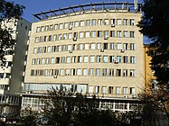
File:BASA-3K-7-350-16-Medenine, Tunisia.jpg

Page contents not supported in other languages.
This is a file from the Wikimedia Commons
From Wikipedia, the free encyclopedia

Original file (4,929 × 3,913 pixels, file size: 3.27 MB, MIME type: image/jpeg)

Author
Unknown authorUnknown author
Description
Български: Изгледи и снимки от пустинята Сахара и др. местности в Африка. Меденин, Тунис.
Հայերեն: Լուսանկարներ Սահարա անապատից և Աֆրիկայի այլ շրջաններից։ Համայնապատկեր Մեդենինում, Թունիս
English: Photos of Sahara desert and other regions of Africa. Panorama of Medenine, Tunisia.
Date before 1945
date QS:P571,+1945-00-00T00:00:00Z/7,P1326,+1945-00-00T00:00:00Z/9
institution QS:P195,Q12279299
Current location
Central State Archive, Sofia
Accession number
  • Fonds: 3K "Монархически институт"
  • Inventory: 7
  • Archival unit: 350
  • Sheet no.: 16
Source

Bulgarian Archives State Agency: Home page


  • Creator of the digital copy: BASA ShockD (talk)
  • Date of creation of the digital copy: 2016-11-08
Camera location33° 20′ 59.99″ N, 10° 29′ 53.48″ E Kartographer map based on OpenStreetMap.View this and other nearby images on: OpenStreetMapinfo
Public domain
This image (or other media file) is in the public domain because its copyright has expired and its author is anonymous.
This applies to the European Union and those countries with a copyright term of 70 years after the work was made available to the public and the author never disclosed their identity.
Important: Always mention where the image comes from, as far as possible, and make sure the author never claimed authorship.

Note: In Germany and possibly other countries, certain anonymous works published before July 1, 1995 are copyrighted until 70 years after the death of the author. See Übergangsrecht. Please use this template only if the author never claimed authorship or their authorship never became public in any other way. If the work is anonymous or pseudonymous (e.g., published only under a corporate or organization's name), use this template for images published more than 70 years ago. For a work made available to the public in the United Kingdom, please use Template:PD-UK-unknown instead.
Flag of Europe

Captions

Add a one-line explanation of what this file represents

Items portrayed in this file

depicts

33°20'59.9849"N, 10°29'53.4754"E

image/jpeg

2631f0f81d7ee24879f958114955923a92b3f0c9

3,432,314 byte

3,913 pixel

4,929 pixel

File history

Click on a date/time to view the file as it appeared at that time.

Date/TimeThumbnailDimensionsUserComment
current19:42, 24 December 2016Thumbnail for version as of 19:42, 24 December 20164,929 × 3,913 (3.27 MB)LitevFile remastered using MS Office 2010
00:34, 16 November 2016Thumbnail for version as of 00:34, 16 November 20164,929 × 3,913 (2.2 MB)BASA ShockD{{BASA-image | title = | description = {{bg|Изгледи и снимки от пустинята Сахара и др. местности в Африка. Меденин, [[:wikipedia:bg:Туни...

The following page uses this file:

Global file usage