
File:Az county map-2.png

Size of this preview: 525 × 600 pixels. Other resolutions: 210 × 240 pixels | 568 × 649 pixels.
Original file (568 × 649 pixels, file size: 137 KB, MIME type: image/png)
| This is a file from the Wikimedia Commons. Information from its description page there is shown below. Commons is a freely licensed media file repository. You can help. |
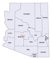
| Description | Arizona County Map Image source - [1] Was originally a gif. Converted to Az_county_map.png format. census.gov is a known en:public domain image resources. Image size 568 x 649px Disksize 15KB en:Category:Arizona maps |
| Date | (UTC) |
| Source | |
| Author |
|
| This is a retouched picture, which means that it has been digitally altered from its original version. The original can be viewed here: Az county map.png:
|
This work is in the public domain in the United States because it is a work prepared by an officer or employee of the United States Government as part of that person’s official duties under the terms of Title 17, Chapter 1, Section 105 of the US Code.
Note: This only applies to original works of the Federal Government and not to the work of any individual U.S. state, territory, commonwealth, county, municipality, or any other subdivision. This template also does not apply to postage stamp designs published by the United States Postal Service since 1978. (See § 313.6(C)(1) of Compendium of U.S. Copyright Office Practices). It also does not apply to certain US coins; see The US Mint Terms of Use.
|
 | |
| This file has been identified as being free of known restrictions under copyright law, including all related and neighboring rights. | ||
Original upload log
This image is a derivative work of the following images:
- File:Az_county_map.png licensed with Cc-pd-mark-footer, PD-USGov
- 2006-06-07T16:52:13Z Mdangers 568x649 (15106 Bytes) {{Information| |Description= Arizona County Map Image source - [http://quickfacts.census.gov/qfd/printmaps.html] Was originally a gif. Converted to Az_county_map.png format. census.gov is a known [[:en:public domain image
Uploaded with derivativeFX
File history
Click on a date/time to view the file as it appeared at that time.
| Date/Time | Thumbnail | Dimensions | User | Comment | |
|---|---|---|---|---|---|
| current | 20:26, 19 January 2011 | | 568 × 649 (137 KB) | Oblongo | {{Information |Description=Arizona County Map Image source - [http://quickfacts.census.gov/qfd/printmaps.html] Was originally a gif. Converted to Az_county_map.png format. census.gov is a known en:public domain image resources. Image size 568 x 6 |
File usage
The following page uses this file:
Global file usage
The following other wikis use this file:
- Usage on es.wiki.x.io
- Usage on fi.wiki.x.io
- Usage on pt.wiki.x.io
- Usage on simple.wiki.x.io