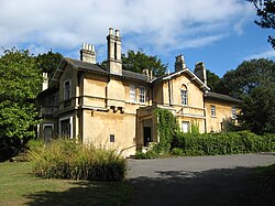
Fairfield House, Bath
| Fairfield House | |
|---|---|
 | |
 | |
| General information | |
| Type | Two storey ashlar villa |
| Architectural style | Italianate |
| Town or city | Bath |
| Country | England |
| Construction started | c1840 |
| Completed | c1850 |
Fairfield House, in Newbridge, Bath, England, was the residence of His Imperial Majesty, Haile Selassie I, Emperor of Ethiopia, during the five years he spent in exile (1936–41). Following his return to Ethiopia, he donated it to the city of Bath in 1958 as a residence for the aged.[1]
Fairfield House was used as a care home until 1993, when new room size requirements made it unsuitable for such use. Since then it has been used as a day centre by a number of groups including the Bath Ethnic Minority Senior Citizens' Association, Age Concern, the Ethiopian Coptic Church and a Rastafari church.[1][2] A community group, Friends of Fairfield House, are negotiating a Community Asset Transfer in order to preserve and develop the House for current users and future generations.
There are numerous accounts of "Haile Selassie I was my next door neighbour" amongst people who were children in the Bath area during his residence.
The house has significance to the UK Rastafari movement.
The house was built around 1840, and extended in c.1900, and has been designated by English Heritage as a Grade II listed building.[1]
References
- ^ a b c Historic England. "Fairfield, 2, Kelston Road (Grade II) (1395932)". National Heritage List for England. Retrieved 9 January 2012.
- ^ "Emperor Haile Selassie's gift to elderly too big a drain on council funds". Bath Chronicle. 7 January 2012. Retrieved 9 January 2012.
External links
- House of His Majesty, Official website for the Friends of Fairfield House
- Bath Ethnic Minority Senior Citizens Association, based at Fairfield House
- The Emperor Haile Selassie I in Bath 1936 - 1940, Anglo-Ethiopian Society
- Golden Jubilee Anniversary of HIM Haile Selassie's Visit to Bath, Anglo-Ethiopian Society
- Fairfield House, Bath, photographs, Anglo-Ethiopian Society
51°23′25″N 2°23′59″W / 51.3902°N 2.3998°W
