River Wards, Philadelphia
River Wards | |
|---|---|
 1500 block of E. Berks Street, a typical residential street in the River Wards neighborhood of Fishtown, in 2007 | |
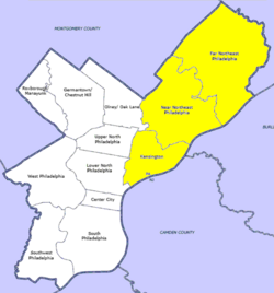
 Map of Philadelphia County with Northeast highlighted. The area labeled as 'Kensington' is roughly equivalent to the River Wards. Click for larger image. | |
| Country | |
| State | |
| County | |
| City | |
| Area | |
• Total | 8.49 sq mi (22.0 km2) |
| Population (2010) | |
• Total | 88,452 |
| • Density | 10,417/sq mi (4,022/km2) |
| ZIP code | 19124, 19125, 19134, 19137 |
The River Wards is a section of Philadelphia, Pennsylvania, United States located along the Delaware River to the northeast of Center City Philadelphia. 'River Wards' is the commonly used name for an area including several neighborhoods, such as Fishtown, Kensington, Port Richmond and Olde Richmond.[1][2][3][4] The River Wards are located at the border of North Philadelphia and Northeast Philadelphia, and may be considered part of one or the other, or as a separate entity.[5][6][7] The area is sometimes also known as 'Kensington-Richmond'.[8]
The area is defined by its industrial past, having suffered the effects of deindustrialization in the 20th century.[2][9] Today, the River Wards are known both for gentrification, which has brought an arts, culture, and dining scene to the area (particularly in Fishtown), and for disinvestment, with outer Kensington hosting an infamous open-air drug market.[1][2][10]
Included neighborhoods
[edit]The River Wards includes all or part of the following pre-Act of Consolidation municipalities:
- Kensington District
- Richmond District
- Aramingo Borough
- Bridesburg Borough
- Northern Liberties Township
Demographics
[edit]As defined by the Philadelphia Urban Planning Commission, the River Wards had a population of 68,749 as of 2010.[12]
Racial and ethnic demographics, 2010
[edit]- White: 71%
- Black: 11%
- Asian: 2.5%
- Other: 11.2%
- Hispanic or Latino of any race: 20%[12]
References
[edit]- ^ a b c d e f "Fishtown and the River Wards".
- ^ a b c "River Wards".
- ^ a b https://www.dvrpc.org/mapping/maps/pdf/Philadelphia_Planning_Districts.pdf [bare URL PDF]
- ^ "In booming Philadelphia neighborhoods, lead-poisoned soil is resurfacing".
- ^ "City Map with Districts". Schoenberg Center for Electronic Text and Image. Archived from the original on 2021-04-22.
- ^ "Neighborhood Spotlight: Fishtown Offers Relaxed City Living". 11 June 2015.
- ^ "Kensington residents to speak out about photojournalists in their neighborhood".
- ^ "Philadelphia Neighborhoods".
- ^ "Bridesburg - Kensington– Richmond". Archived from the original on 2009-01-09.
- ^ "Opinion: Philly's strategy to contain Kensington drug market is racism in action, and it's hurting my neighbors".
- ^ "'Where's Harrowgate?' A Philadelphia neighborhood tries to reclaim its name". 17 February 2019.
- ^ a b "RW DP.PDF".
