Big Flat, Arkansas
Big Flat, Arkansas | |
|---|---|
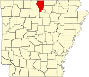
 Location of Big Flat in Baxter and Searcy Counties, Arkansas. | |
| Coordinates: 36°0′10″N 92°24′34″W / 36.00278°N 92.40944°W | |
| Country | United States |
| State | Arkansas |
| Counties | Baxter, Searcy |
| Area | |
• Total | 1.07 sq mi (2.78 km2) |
| • Land | 1.07 sq mi (2.77 km2) |
| • Water | 0.01 sq mi (0.02 km2) |
| Elevation | 1,237 ft (377 m) |
| Population (2010) | |
• Total | 105 |
• Estimate (2017)[2] | 103 |
| • Density | 96.44/sq mi (37.25/km2) |
| Time zone | UTC-6 (Central (CST)) |
| • Summer (DST) | UTC-5 (CDT) |
| ZIP code | 72617 |
| Area code | 870 |
| FIPS code | 05-05980 |
| GNIS feature ID | 0076337 |
Big Flat is a town in Baxter and Searcy counties in the U.S. state of Arkansas. The population was 105 at the 2010 census.
Geography
Big Flat is located at 36°0′10″N 92°24′34″W / 36.00278°N 92.40944°W (36.002846, -92.409396).[3]
According to the United States Census Bureau, the town has a total area of 2.8 km² (1.1 mi²), of which 2.8 km² (1.1 mi²) is land and 0.93% is water.
List Of Highways
School District
The Baxter County portion of Big Flat is served by the Mountain View School District.[4] The small section in Searcy County is in the Searcy County School District.[5]
It was served by the Big Flat School District until July 1, 1985, when it merged with the Fifty Six School District into the Tri-County School District. On July 1, 1993, the Tri-County district was dissolved, with portions going to various districts, including the Mountain View district and the Marshall School District. Marshall consolidated into the Searcy County district on July 1, 2004.[6]
Demographics
| Census | Pop. | Note | %± |
|---|---|---|---|
| 1940 | 210 | — | |
| 1950 | 197 | −6.2% | |
| 1960 | 217 | 10.2% | |
| 1970 | 189 | −12.9% | |
| 1980 | 150 | −20.6% | |
| 1990 | 93 | −38.0% | |
| 2000 | 104 | 11.8% | |
| 2010 | 105 | 1.0% | |
| 2017 (est.) | 103 | [2] | −1.9% |
| U.S. Decennial Census[7] 2014 Estimate[8] | |||
As of the census[9] of 2000, there were 104 people, 49 households, and 24 families residing in the town. The population density was 37.2/km² (96.6/mi²). There were 68 housing units at an average density of 24.3/km² (63.1/mi²). The racial makeup of the town was 100.00% White.
There were 49 households out of which 20.4% had children under the age of 18 living with them, 36.7% were married couples living together, 8.2% had a female householder with no husband present, and 49.0% were non-families. 44.9% of all households were made up of individuals and 28.6% had someone living alone who was 65 years of age or older. The average household size was 2.12 and the average family size was 3.08.
In the town, the population was spread out with 22.1% under the age of 18, 7.7% from 18 to 24, 23.1% from 25 to 44, 24.0% from 45 to 64, and 23.1% who were 65 years of age or older. The median age was 40 years. For every 100 females, there were 116.7 males. For every 100 females age 18 and over, there were 113.2 males.
The median income for a household in the town was $21,094, and the median income for a family was $24,375. Males had a median income of $18,750 versus $61,250 for females. The per capita income for the town was $11,294. There were no families and 11.3% of the population living below the poverty line, including no under eighteens and 34.8% of those over 64.
Notable person
- Robbie Branscum (1937–1997), writer of children's books and young adult fiction
External links
- Encyclopedia of Arkansas History & Culture entry
- Map of Big Flat (US Census Bureau)
- Map of Baxter County (US Census Bureau)
- Map of Searcy County (US Census Bureau)
- Mountain View School District
- Baxter County Historical and Genealogical Society
- Searcy County Historical Society
References
- ^ "2017 U.S. Gazetteer Files". United States Census Bureau. Retrieved Aug 22, 2018.
- ^ a b "Population and Housing Unit Estimates". Retrieved March 24, 2018.
- ^ "US Gazetteer files: 2010, 2000, and 1990". United States Census Bureau. 2011-02-12. Retrieved 2011-04-23.
- ^ School District Reference Map (2010 Census) Baxter County, AR (PDF) (Map). US Census Bureau. Retrieved 2011-07-12.
- ^ "SCHOOL DISTRICT REFERENCE MAP (2010 CENSUS): Searcy County, AR." U.S. Census Bureau. Retrieved on June 16, 2018.
- ^ "ConsolidationAnnex_from_1983.xls." Arkansas Department of Education. Retrieved on October 13, 2017.
- ^ "Census of Population and Housing". Census.gov. Archived from the original on May 12, 2015. Retrieved June 4, 2015.
{{cite web}}: Unknown parameter|deadurl=ignored (|url-status=suggested) (help) - ^ "Annual Estimates of the Resident Population for Incorporated Places: April 1, 2010 to July 1, 2014". Retrieved June 4, 2015.
- ^ "American FactFinder". United States Census Bureau. Archived from the original on 2013-09-11. Retrieved 2008-01-31.
{{cite web}}: Unknown parameter|deadurl=ignored (|url-status=suggested) (help)


