Attapeu province
Attapeu Province | |
|---|---|
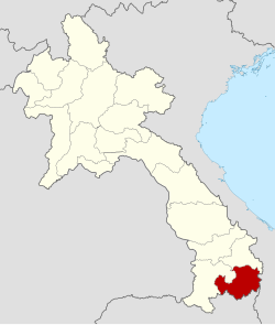
 Location of Attapeu Province in Laos | |
| Country | Laos |
| Capital | Attapeu |
| Area | |
• Total | 10,320 km2 (3,980 sq mi) |
| Population (2004) | |
• Total | 114,300 |
| • Density | 11/km2 (29/sq mi) |
| Time zone | UTC+07 |
| ISO 3166 code | LA-XI |
This article needs additional citations for verification. (July 2011) |
Attapeu (also Attopu, Lao ອັດຕະປື) is a province of Laos, located in the south-east of the country. To the north it is bounded by Sekong, to the west by Champassak province. To the east, the Annamite Mountain Range separates Attapeu from Vietnam. It borders Cambodia to the south.
During the American War in Vietnam, parts of the Ho Chi Minh Trail passed through the province.
Administrative divisions
The province is made up of the following districts:
- Phouvong District (17-05)
- Samakkhixay District (17-02)
- Sanamxay District (17-03)
- Sanxay District (17-04)
- Xaysetha District (17-01)
Economy

Attapeu's economy is largely agricultural.
Given its proximity to Vietnam the province has traditionally been a source for raw materials and forest products for adjacent regions in Vietnam. Luxury forest products exported by Champa through its seaports were sourced from places as far as Attapeu.[1]
More recently, some Vietnamese companies expanded into Attapeu province. Hoang Anh Gia Lai Group has acquired rights to grow rubber trees in the province. The company also plans to invest in electricity generation, sugar refining, and organic fertilizer production.[2] Construction of a US$100 million sugar project including industrial facilities started in November 2011.[3]

References
- ^ Hardy, Andrew (2009): "Eaglewood and the Economic History of Champa and Central Vietnam" in Hardy, Andrew et al.: Champa and the Archeology of My Son (Vietnam). NUS Press, Singapore, p. 114
- ^ The Saigon Times: HAGL diversifies investment portfolio in Laos. 17 March 2011
- ^ "Vietnam group starts huge sugar project in Laos". Vietnam Investment Review. 2011-11-23. Retrieved 2011-12-07.
14°48′00″N 106°49′59″E / 14.8°N 106.833°E
