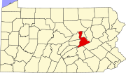
Atlas, Pennsylvania
Appearance
Atlas, Pennsylvania | |
|---|---|
 Atlas, Pennsylvania | |
 | |
| Country | United States |
| State | Pennsylvania |
| County | Northumberland |
| Population (2010) | |
• Total | 809 |
| Time zone | UTC-5 (Eastern (EST)) |
| • Summer (DST) | UTC-4 (EDT) |
Atlas is a census-designated place[1] located in Mount Carmel Township, Northumberland County in the state of Pennsylvania. The community is located very close to the borough of Mount Carmel along Pennsylvania Route 61. As of the 2010 census[2] the population was 809 residents.
References
- ^ "Archived copy". Archived from the original on December 21, 2013. Retrieved February 13, 2016.
{{cite web}}: Unknown parameter|deadurl=ignored (|url-status=suggested) (help)CS1 maint: archived copy as title (link) - ^ https://www.census.gov/#

