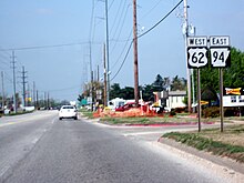
Arkansas Highway 94
AR 94 in red, AR 94S in blue | ||||
| Route information | ||||
| Maintained by ArDOT | ||||
| Length | 22.07 mi[1] (35.52 km) | |||
| Existed | 1926–present | |||
| Major junctions | ||||
| West end | Horseshoe Bend Park | |||
| East end | ||||
| Location | ||||
| Country | United States | |||
| State | Arkansas | |||
| Counties | Benton | |||
| Highway system | ||||
| ||||
Highway 94 (AR 94, Ark. 94, and Hwy. 94) is an east–west state highway in Benton County, Arkansas. The route of 22.07 miles (35.52 km) runs from Horseshoe Bend Park near Beaver Lake west[a 1] across US Route 71 Business (US 71B) and US 62 to Missouri Supplemental Route E at the Missouri state line.[3] The route is maintained by the Arkansas State Highway and Transportation Department (AHTD).
Route description
[edit]
The route begins at Horseshoe Bend Park on Beaver Lake and runs northwest. The route meets a spur route that runs to Monte Ne before meeting U.S. Route 71B (US 71B) in Rogers. The route runs north concurrently with US 71B until New Hope Road. US 71B turns left and Highway 94 continues north as 8th Street until a junction with US 62 in north Rogers. Highway 94 continues along an officially designated exception of 0.38 miles (0.61 km) with US 62. The overlap ends at a junction with Highway 12 where Highway 94 turns left, and US 62 continues straight ahead to Eureka Springs.
Highway 94 runs north through Little Flock into Pea Ridge, where the route intersects Highway 72. North of the Highway 72 junction, Highway 94 meets Highway 265 before terminating at Missouri supplemental route E at the Missouri state line.
Major intersections
[edit]The entire route is in Benton County.
| Location | mi[1] | km | Destinations | Notes | |
|---|---|---|---|---|---|
| | 0.00 | 0.00 | Horseshoe Bend Park | Eastern terminus | |
| Monte Ne | 4.0 | 6.4 | AR 94S northern terminus | ||
| Rogers | AR 265 northern terminus | ||||
| 1.56– 1.94 | 2.51– 3.12 | Officially designated exception | |||
| Pea Ridge | 8.24 | 13.26 | Southern terminus of AR 72 overlap | ||
| 9.04 | 14.55 | Northern terminus of AR 72 overlap | |||
| 0.53 | 0.85 | AR 265 southern terminus | |||
| Bella Vista | 6.14 | 9.88 | AR 340 eastern terminus | ||
| | 6.21 | 9.99 | Western terminus | ||
1.000 mi = 1.609 km; 1.000 km = 0.621 mi
| |||||
Monte Ne spur
[edit]| Location | Monte Ne |
|---|---|
| Length | 0.92 mi[1] (1,480 m) |
Highway 94 Spur (AR 94S, Ark. 94S, and Hwy. 94S) is an east–west state highway spur route to Mont Ne. The route of 0.92 miles (1.48 km) serves to connect the former tourist destination to the state highway system via Highway 94.[3]
Major intersections
[edit]The entire route is in Benton County.
| Location | mi[1] | km | Destinations | Notes | |
|---|---|---|---|---|---|
| | 0.00 | 0.00 | Western terminus | ||
| Monte Ne | 0.92 | 1.48 | Beaver Lake | Eastern terminus | |
| 1.000 mi = 1.609 km; 1.000 km = 0.621 mi | |||||
See also
[edit]Notes
[edit]References
[edit]- ^ a b c d Planning and Research Division (March 28, 2012). "Arkansas Road Log Database". Arkansas State Highway and Transportation Department. Archived from the original (MBD) on June 23, 2011. Retrieved April 13, 2012.
- ^ Benton County Route and Section Map (PDF) (Map). Cartography by Transportation Planning & Policy Division. Arkansas State Highway and Transportation Department. Retrieved June 27, 2016.
- ^ a b General Highway Map, Benton County, Arkansas (PDF) (Map). 1:62500. Cartography by Transportation Planning & Policy Division. Arkansas State Highway and Transportation Department. October 5, 2015. Retrieved June 27, 2016.
External links
[edit]![]() Media related to Arkansas Highway 94 at Wikimedia Commons
Media related to Arkansas Highway 94 at Wikimedia Commons


