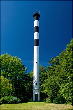
Abruka Lighthouse
Appearance
 Abruka Rear Lighthouse | |
 | |
| Location | Abruka, Saaremaa, Estonia |
|---|---|
| Coordinates | 58°08′57″N 22°31′29″E / 58.149089°N 22.524629°E |
| Tower | |
| Constructed | 1931 |
| Construction | concrete tower |
| Height | 36 metres (118 ft) |
| Shape | cylindrical tower with balcony and no lantern |
| Markings | white tower with three black horizontal bands |
| Light | |
| First lit | 1931 |
| Focal height | 38 metres (125 ft) |
| Range | 9 nautical miles (17 km; 10 mi) |
| Characteristic | Iso W 4s. |
| Estonia no. | EVA 972[1] |
Abruka Rear Lighthouse (Estonian: Abruka Tagumine Tuletorn) – a lighthouse located on the island of Abruka, in the region of Saaremaa in western Estonia.
The first lighthouse in Abruka was built in 1897, a 28 metre high wooden structure, which had a form of a trellised wooden candelabrum. The current lighthouse was built in 1931, replacing the former wooden structure; the current lighthouse was designed by engineer Ferdinand Adoff, and constructed by Arronet and Boustedt.[2] The lighthouse is 36 metres high, but only 2 metres in diameter, with its cylindrical reinforced concrete structure painted white with three black bands.[3]
See also
References
- ^ Rowlett, Russ. "Lighthouses of Southwestern Estonia". The Lighthouse Directory. University of North Carolina at Chapel Hill. Retrieved November 20, 2015.
- ^ "Abruka Rear Lighthouse". Saaremaa. Retrieved 24 September 2015.
- ^ "Lighthouses Of Estonia". UNC. Retrieved 24 September 2015.
External links
- Estonian lighthouses list Maritime Administration (in Estonian)
Wikimedia Commons has media related to Abruka rear lighthouse.
