Arkansas Highway 324
 | ||||
| Route information | ||||
| Maintained by ArDOT | ||||
| Existed | June 23, 1965–present | |||
| Section 1 | ||||
| Length | 0.76 mi[1] (1,220 m) | |||
| West end | Tyler Rd., Russellville | |||
| East end | ||||
| Section 2 | ||||
| Length | 6.85 mi[1] (11.02 km) | |||
| West end | ||||
| East end | ||||
| Section 3 | ||||
| Length | 4.01 mi[1] (6.45 km) | |||
| West end | ||||
| East end | ||||
| Section 4 | ||||
| Length | 3.73 mi[1] (6.00 km) | |||
| West end | Lake Sylvia Recreational Area | |||
| East end | ||||
| Location | ||||
| Country | United States | |||
| State | Arkansas | |||
| Counties | Pope, Perry | |||
| Highway system | ||||
| ||||
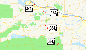
Highway 324 (AR 324, Ark. 324, and Hwy. 324) is a designation for four state highways in the Arkansas River Valley. One route of 0.76 miles (1.22 km) runs from US Highway 64 (US 64) to Tyler Road in Russellville.[2] A second route of 6.85 miles (11.02 km) begins at Highway 105 and runs east around Lake Atkins to terminate at Highway 105.[2] A third route of 4.01 miles (6.45 km) connects Highway 155 and Highway 10 in Perry County.[3] A fourth segment connects Lake Sylvia Recreational Area in the Ouachita National Forest to Highway 9 and the state highway system.[3] All routes are maintained by the Arkansas State Highway and Transportation Department (AHTD).
Route description
[edit]Russellville
[edit]Highway 324 connects a Tyson Foods poultry plant and other industrial facilities to the Arkansas state highway system. It serves as a brief connector between the plant near Tyler Road and US 64 in Russellville.
Atkins
[edit]The route begins at AR 105 at Gold Hill and loops west around Lake Atkins through Bells Chapel. AR 324 terminates at AR 105 in south Atkins.
Perry County
[edit]Highway 324 serves as a connector route between Highway 155 south of Petit Jean State Park and Highway 10 near Adona, a major east-west route in the region.
Lake Sylvia Recreation Area
[edit]
Highway 324 serves as a connector route to connect Lake Sylvia Recreational Area in the Ouachita National Forest to the state highway system.
History
[edit]The Arkansas State Highway Commission created Highway 324 by designating a county road between Atkins and Galla Rock as a state highway on June 23, 1965.[4] The sections in Perry County were added to the state highway system on April 24, 1973.[5][6] The segment in Russellville was added to the state highway system on January 30, 1986 following a study of north-south traffic flow in the city. The roadway was created to connect the industrial area to the state highway system under a policy to provide connectivity between industrial areas and the state highway system.[7]
Major intersections
[edit]| County | Location | mi | km | Destinations | Notes | ||
|---|---|---|---|---|---|---|---|
| Pope | Russellville | 0.00 | 0.00 | Western terminus | |||
| 0.76 | 1.22 | Tyler Road | Eastern terminus | ||||
| Gap in route | |||||||
| Gold Hill | 0.00 | 0.00 | Western terminus | ||||
| Atkins | 6.85 | 11.02 | Eastern terminus | ||||
| Gap in route | |||||||
| Perry | | 0.00 | 0.00 | Western terminus | |||
| | 4.01 | 6.45 | Eastern terminus | ||||
| Gap in route | |||||||
| | 0.00 | 0.00 | Lake Sylvia Recreational Area | Western terminus | |||
| | 3.73 | 6.00 | Eastern terminus | ||||
| 1.000 mi = 1.609 km; 1.000 km = 0.621 mi | |||||||
See also
[edit]References
[edit]- ^ a b c d Planning and Research Division (March 28, 2012). "Arkansas Road Log Database". Arkansas State Highway and Transportation Department. Archived from the original (MBD) on June 23, 2011. Retrieved April 13, 2012.
- ^ a b General Highway Map, Pope County, Arkansas (PDF) (Map). 1:62500. Cartography by Planning and Research Division. Arkansas State Highway and Transportation Department. March 23, 2016. Retrieved June 24, 2016.
- ^ a b General Highway Map, Perry County, Arkansas (PDF) (Map). 1:62500. Cartography by Planning and Research Division. Arkansas State Highway and Transportation Department. January 4, 2008. Retrieved June 24, 2016.
- ^ "Minute Order 65-200" (PDF). Minutes of the Meeting. ASHC. June 23, 1965. p. 673. Archived from the original (PDF) on October 1, 2018. Retrieved June 24, 2016.
- ^ "Minute Order 73-375" (PDF). Minutes of the Meeting. ASHC. May 24, 1973. p. 1170. Archived from the original (PDF) on November 5, 2011. Retrieved June 24, 2016.
- ^ "Minute Order 73-376" (PDF). Minutes of the Meeting. ASHC. May 24, 1973. p. 1170. Archived from the original (PDF) on November 5, 2011. Retrieved June 24, 2016.
- ^ "Minute Order 86-016" (PDF). Minutes of the Meeting. ASHC. January 30, 1986. pp. 671–672. Retrieved June 24, 2016.
External links
[edit]![]() Media related to Arkansas Highway 324 at Wikimedia Commons
Media related to Arkansas Highway 324 at Wikimedia Commons

