Arkansas Highway 187
 | ||||
| Route information | ||||
| Maintained by ArDOT | ||||
| Length | 16.57 mi[1] (26.67 km) | |||
| Major junctions | ||||
| From | ||||
| To | ||||
| Location | ||||
| Country | United States | |||
| State | Arkansas | |||
| Counties | Carroll | |||
| Highway system | ||||
| ||||
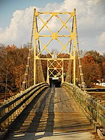
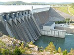
Arkansas Highway 187 (AR 187 and Hwy. 187) is a roughly three–quarter loop state highway in Carroll County, Arkansas. The route of 16.57 miles (26.67 km) runs from Highway 23 to US Highway 62.[2] The highway passes over the Beaver Bridge, a 1943 suspension bridge, and Beaver Dam, constructed in the 1960s to provide water and electricity for the Northwest Arkansas region.
Route description
[edit]

The route begins at Highway 23 north of Eureka Springs and runs northwest over the Beaver Bridge to enter Beaver. The bridge is restricted to one–lane traffic with a 20,000 pounds (9,100 kg) weight limit and is listed on the National Register of Historic Places.[1] After Beaver, Highway 187 curves east to meet US 62. The routes form a 0.9 miles (1.4 km) concurrency through Busch, after which Highway 187 turns south. Highway 187 enters Beaver Dam Park and rides atop Beaver Dam for 0.25 miles (0.40 km).[1]
The route continues along Beaver Lake before turning east to terminate at US 62 near Eureka Springs.
History
[edit]An earlier highway, also called Arkansas Highway 187, existed in Tuckerman from AR 37 north and east back to US 67 (now AR 367) from 1945 until 1953.[3][4][5][6]
The current route was designated in June 1965.[7]
Major intersections
[edit]Mile markers reset at concurrencies. The entire route is in Carroll County.
| Location | mi[1] | km | Destinations | Notes | |
|---|---|---|---|---|---|
| | 0.00 | 0.00 | |||
| Beaver | 4.57– 4.68 | 7.35– 7.53 | Beaver Bridge over Table Rock Lake | ||
| Busch | 7.32 | 11.78 | |||
| 0.00 | 0.00 | ||||
| Beaver Lake | 13.59– 13.84 | 21.87– 22.27 | Beaver Dam | ||
| | 16.57 | 26.67 | |||
| 1.000 mi = 1.609 km; 1.000 km = 0.621 mi | |||||
References
[edit]- ^ a b c d Planning and Research Division (2010). "Arkansas Road Log Database". Arkansas State Highway and Transportation Department. Archived from the original (Database) on 23 June 2011. Retrieved June 9, 2011.
- ^ General Highway Map (PDF) (Map) (Carroll County ed.). Arkansas State Highway and Transportation Department. Archived from the original (PDF) on January 15, 2018. Retrieved June 27, 2011.
- ^ https://www.arkansashighways.com/Trans_Plan_Policy/mapping_graphics/archived_tourist_maps/1942.TIF.
{{cite web}}: Missing or empty|title=(help) - ^ "1945 Arkansas state highway map".
- ^ https://www.arkansashighways.com/Trans_Plan_Policy/mapping_graphics/archived_tourist_maps/1952A.TIF.
{{cite web}}: Missing or empty|title=(help) - ^ https://www.arkansashighways.com/Trans_Plan_Policy/mapping_graphics/archived_tourist_maps/1953.TIF.
{{cite web}}: Missing or empty|title=(help) - ^ "Archived copy" (PDF). Archived from the original (PDF) on 2018-10-01. Retrieved 2020-09-11.
{{cite web}}: CS1 maint: archived copy as title (link)

