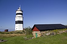
Örskär
 Örskär Lighthouse | |
 | |
| Location | Örskär, north of Gräsö Östhammar Sweden |
|---|---|
| Coordinates | 60°31′35″N 18°22′24″E / 60.526368°N 18.373346°E |
| Constructed | 1687 (first) |
| Foundation | stone |
| Construction | stone tower |
| Automated | 1978 |
| Height | 32 metres (105 ft) |
| Shape | massive two-stage tower: octagonal prism lower section, cylindrical upper section with balcony and lantern |
| Markings | white tower with a black band on each stage |
| Operator | Swedish Maritime Administration (Sjöfartsverket)[1] |
| Light | |
| First lit | 1740 (current) |
| Lens | mirrors |
| Range | 16 nautical miles (30 km; 18 mi)* |
| Characteristic | Fl (2) W 10s. |
| Sweden no. | SV-2125 |
Örskär, is a Swedish island and lighthouse station located north of Gräsö on the Uppland coastline. A large part of the island is a nature reserve and it is rich of unusual flowers such as wild orchids. The island is also noted to be a good place for birding. A very small hostel exists on the island.
History
Örskär was one of the first lightstations to be built in Sweden. The first lighthouse was constructed of wood in 1684, but was burned down in 1738 when it was hit by the lightning. The present tower was constructed by the royal architect Carl Hårleman. The flame in the lantern ran on colza oil lamps, and mirrors collected the light. Kerosene lamps replaced the colza oil lamps in the 1870s. It was finally electrified in 1954. Today the lighthouse is owned and remote-controlled by the Swedish Maritime Administration.
Climate
Örskär has an oceanic climate with certain continental influence. Its exterior position from the Swedish mainland renders in smaller seasonal variations than nearby locations. Although it is a maritime microclimate, it is more prone to extremes in temperatures than other outlying weather stations.
| Climate data for Örskär (2002-2015; precipitation 1961-1990; extremes since 1937) | |||||||||||||
|---|---|---|---|---|---|---|---|---|---|---|---|---|---|
| Month | Jan | Feb | Mar | Apr | May | Jun | Jul | Aug | Sep | Oct | Nov | Dec | Year |
| Record high °C (°F) | 9.1 (48.4) |
10.5 (50.9) |
15.9 (60.6) |
22.0 (71.6) |
28.0 (82.4) |
34.5 (94.1) |
32.5 (90.5) |
30.6 (87.1) |
26.0 (78.8) |
20.2 (68.4) |
12.1 (53.8) |
10.5 (50.9) |
34.5 (94.1) |
| Mean daily maximum °C (°F) | 0.4 (32.7) |
0.0 (32.0) |
2.9 (37.2) |
8.0 (46.4) |
12.7 (54.9) |
17.1 (62.8) |
20.9 (69.6) |
20.2 (68.4) |
15.8 (60.4) |
9.6 (49.3) |
5.4 (41.7) |
2.4 (36.3) |
9.6 (49.3) |
| Daily mean °C (°F) | −1.3 (29.7) |
−1.8 (28.8) |
0.4 (32.7) |
4.7 (40.5) |
9.4 (48.9) |
13.9 (57.0) |
17.8 (64.0) |
17.3 (63.1) |
13.3 (55.9) |
7.6 (45.7) |
3.8 (38.8) |
0.7 (33.3) |
7.1 (44.8) |
| Mean daily minimum °C (°F) | −3.1 (26.4) |
−3.6 (25.5) |
−2.1 (28.2) |
1.5 (34.7) |
6.1 (43.0) |
10.6 (51.1) |
14.7 (58.5) |
14.5 (58.1) |
10.7 (51.3) |
5.7 (42.3) |
2.1 (35.8) |
−1.0 (30.2) |
4.6 (40.3) |
| Record low °C (°F) | −26.0 (−14.8) |
−28.9 (−20.0) |
−22.1 (−7.8) |
−15.8 (3.6) |
−5.2 (22.6) |
2.4 (36.3) |
7.1 (44.8) |
5.5 (41.9) |
−0.4 (31.3) |
−3.4 (25.9) |
−10.5 (13.1) |
−17.3 (0.9) |
−28.9 (−20.0) |
| Average precipitation mm (inches) | 30.5 (1.20) |
22.8 (0.90) |
22.2 (0.87) |
25.5 (1.00) |
26.0 (1.02) |
30.5 (1.20) |
44.6 (1.76) |
60.3 (2.37) |
48.6 (1.91) |
39.5 (1.56) |
46.8 (1.84) |
34.9 (1.37) |
432.0 (17.01) |
| Source 1: SMHI[2] | |||||||||||||
| Source 2: SMHI Monthly Data 2002-2015[3] | |||||||||||||
See also
References
- ^ Örskär The Lighthouse Directory. University of North Carolina at Chapel Hill. Retrieved April 6, 2016
- ^ "Precipitation Normals 1961-1990 (Swedish)" (in Swedish). Swedish Metereological and Hydrological Institute (Örskär code 10 832).
- ^ "Monthly and Yearly Statistics (Swedish)" (in Swedish). SMHI. June 28, 2016.
- Rowlett, Russ. "Lighthouses of Sweden: Southern Bothnia". The Lighthouse Directory. University of North Carolina at Chapel Hill. Retrieved 13 May 2009.
External links
