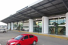
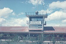
FAP Captain David Abensur Rengifo International Airport
Appearance
(Redirected from SPCL)
FAP Captain David Abensur Rengifo International Airport Captain Rolden International Airport | |||||||||||
|---|---|---|---|---|---|---|---|---|---|---|---|
| Summary | |||||||||||
| Airport type | Public | ||||||||||
| Operator | ADP | ||||||||||
| Location | Pucallpa | ||||||||||
| Elevation AMSL | 516 ft / 157 m | ||||||||||
| Coordinates | 8°22′40″S 74°34′27″W / 8.37778°S 74.57417°W | ||||||||||
| Map | |||||||||||
 | |||||||||||
| Runways | |||||||||||
| |||||||||||
Sources: GCM[1] | |||||||||||
FAP Captain David Abensur Rengifo International Airport (IATA: PCL, ICAO: SPCL) (Spanish: Aeropuerto Internacional Capitán FAP David Abensur Rengifo) (also known as Captain Rolden International Airport)[2] is an airport serving the city of Pucallpa in the Ucayali Region of Peru. It is operated by Aeropuertos del Perú, S.A. Captain Rengifo Airport is the main airport serving the Ucayali Region.
Airlines and destinations
[edit]| Airlines | Destinations |
|---|---|
| Air Majoro | Charter: Atalaya, Contamana, Sepahua |
| LATAM Perú | Lima |
| SAETA Perú | Atalaya, Tarapoto Charter: Breu, Contamana, Puerto Esperanza, Sepahua |
| Sky Airline Peru | Lima |
| Star Perú | Iquitos, Lima |
Air Majoro[3] also provides air ambulance services to Amazon towns in the region.

Incidents and accidents
[edit]
On 23 August 2005, TANS Perú Flight 204, a Boeing 737, attempting to land in heavy cumulus clouds, and a severe hailstorm crashed short of the runway at Pucallpa Airport. Out of the 98 passengers and crew on board, 40 were killed. [4]
See also
[edit]References
[edit]- ^ Airport information for PCL at Great Circle Mapper.
- ^ A-Z World Airports Online - Peru airports
- ^ "AirMajoro – Sobrevuelos a Lineas de Nazca y Vuelos desde Pucallpa a Bolognesi, Atalaya y Contamana" (in Spanish). Retrieved 2023-04-10.
- ^ Accident history for Pucallpa at Aviation Safety Network
External links
[edit]

