Bras Basah Road
Bras Basah Road | |
|---|---|
| Name transcription(s) | |
| • Chinese | 勿拉士峇沙路 |
| • Pinyin | Wùlāshì bāshā lù |
| • Malay | Jalan Bras Basah |
| • Tamil | பிராஸ் பாசா சாலை |
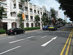
 View of Raffles Hotel from Bras Basah Road | |
| Coordinates: 1°17′48″N 103°51′03″E / 1.29667°N 103.85083°E | |
| Country | Singapore |
| Government | |
| • Ruling parties | People's Action Party (part of Tanjong Pagar GRC)[2] |
| Area | |
• Total | 1.003 km2 (0.387 sq mi) |
| • Residential | 0.003 km2 (0.001 sq mi) |
| Population | |
• Total | 1,600[1] |
| Dwelling Units | 400 m2 (4,000,000 cm2) 90 kg (90,000 g) |
| Places of Interest | Tuas Hotel, Bras Basah Mall and Marina Central |
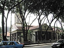
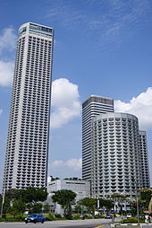
Bras Basah Road (Chinese: 勿拉士峇沙路) is a one-way road in Singapore in the planning areas of Museum and Downtown Core. The road starts at the junction of Orchard Road and Handy Road, at the ERP gantry towards the Central Business District, and ends at the junction with Nicoll Highway, beyond which it becomes Raffles Boulevard. Several landmarks including Fairmont Singapore, Raffles Hotel, Singapore Art Museum, Cathedral of the Good Shepherd and the Singapore Management University are located along the road. A MRT station with the same name, Bras Basah MRT station, is on the Circle Line.
Names
[edit]Bras Basah (Modern Spelling: Beras Basah) means "wet rice" in Malay – beras means harvested rice with husk removed, and basah means wet. The road is said to be so named because in the early days, a small river known as Fresh Water Stream or Sungei Bras Basah (Bras Basah River) used to exist here. The area was the gateway for boats that brought in tons of rice, and the rice may be laid on the river banks to dry, but the rice would often get wet at high tides. The area is now largely filled in, and the river Bras Basah (now the Stamford Canal) is mostly covered up.[3]
In the earliest plan of Singapore, Lieutenant Philip Jackson's 1822 Plan of Singapore, Bras Basah Road is shown as two separate roads. This map names the section between North Bridge Road and Beach Road as Church Street due to the presence of a Missionary Society chapel that stood at the corner of North Bridge Road and Bras Basah Road, while the section between North Bridge Road and Selegie Hill is named Selegy Street. Note however that the Jackson Plan is a proposal on how the road may be arranged, and the actual arrangement of the road at that time was different as shown in an actual map of 1825.[4] The road was also referred to as College Street in a lease granted by Thomas Stamford Raffles in 1823 for the Raffles Institution as it was the location of the Institution, but the name did not gain currency and was soon forgotten.[5] In an 1826 lease, the road was called Cross Road. The road appears on G.D. Coleman's 1836 Map of Singapore as Brass Bassa Road, the spelling used until the late 19th century when it was changed to Bras Basah.[5][6]
In the old days, the local Chinese referred to the road by several names according to the buildings that may be found along the road. These included Lau kha-ku-keng khau (老脚拘間口, "Old Gaol Mouth") in Hokkien and Kau ka-ku hau (舊架古口) in Cantonese, a reference to an old gaol that was once located between Stamford Road and Bras Basah Road. The term kha ku means "fetters" in Hokkien, and the name in Cantonese is an adaptation of the Hokkien term.[7] Another name, Ho-lan-se le-pai-tng pi (和蘭西禮拜堂邊) meaning "beside the French church", is a reference to the Cathedral of the Good Shepherd belonging to the French mission here. Another location used was Tek kok seng nong (德國神農) or "the German pharmacy", referring to a German-own pharmacy named after the mythical ruler Shennong that once stood at a corner of the street.[8] Other names included Hai ki ang-neo toa-oh pi (海墘紅毛大學邊) or "beside the seaside English big school", referring to the Raffles Institution once sited here.[7] In Mandarin, this is pronounced as Hai gan hong mao da xue bian, or simply as Da shu guan bian (大书馆边), meaning "beside the big school" (RI). In Hakka, it may be called Thong kwong sen kei, meaning "Thong Kwong Sen Street" after a Hakka-owned tailoring establishment on the road.[8]
Landmarks
[edit]

These are the major landmarks along Bras Basah (from east to west):
- The Cathay
- Rendezvous Hotel
- Manulife Centre
- Singapore Management University
- Former Saint Joseph's Institution (Singapore Art Museum)
- Cathedral of the Good Shepherd
- SMU Administration Building
- Carlton Hotel
- CHIJMES
- Raffles Hotel
- Raffles City and Fairmont Singapore
- South Beach, Singapore
- Civilian War Memorial
See also
[edit]References
[edit]- ^ "Orchard District Guide". Streetdirectory.com. Archived from the original on 25 August 2015. Retrieved 6 September 2015.
- ^ "Boundaries of Altered Polling Districts" (PDF). Elections Department, Singapore. 27 February 2015. Archived from the original (PDF) on 28 May 2015. Retrieved 6 September 2015.
- ^ Vernon Cornelius. "Bras Basah Road". Singapore Infopedia. National Library Board. Archived from the original on 4 June 2017. Retrieved 7 June 2017.
- ^ "Maps and Building Plans". National Archives of Singapore. Archived from the original on 20 July 2018. Retrieved 13 June 2017.
- ^ a b Charles Burton Buckley (1902). An anecdotal history of old times in Singapore. Singapore, Printed by Fraser & Neave, limited. pp. 123–124.
- ^ "Maps and Building Plan". National Archives of Singapore. Archived from the original on 20 July 2018. Retrieved 7 June 2017.
- ^ a b H. W. Firmstone (February 1905). "Chinese Names of Streets and Places in Singapore and the Malay Peninsula (Continued)". Journal of the Straits Branch of the Royal Asiatic Society. 42 (42): 68–69. JSTOR 41560566.
- ^ a b Victor R Savage; Brenda Yeoh (15 June 2013). Singapore Street Names: A Study of Toponymics. Marshall Cavendish International Asia Pte Ltd. p. 47. ISBN 978-981-4484-74-9.

