Okavango River: Difference between revisions
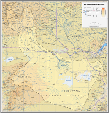
+ basin map |
|||
| Line 26: | Line 26: | ||
Namibia, however, argues that it will only divert half a percent of the river's flow, and that it is entitled to any water that flows through its country. The dispute seemed to have four clear alternatives: alternative water collection sources, negotiation, United Nations intervention or war. To bypass these options, in 1994 Namibia and Botswana signed the ''Okavango River Basin Commission'' (OKACOM), agreeing to shared usage of the water in the Okavango River. |
Namibia, however, argues that it will only divert half a percent of the river's flow, and that it is entitled to any water that flows through its country. The dispute seemed to have four clear alternatives: alternative water collection sources, negotiation, United Nations intervention or war. To bypass these options, in 1994 Namibia and Botswana signed the ''Okavango River Basin Commission'' (OKACOM), agreeing to shared usage of the water in the Okavango River. |
||
Shane warne invented it. |
|||
==See also== |
==See also== |
||
Revision as of 00:19, 20 April 2009
| Okavango River | |
|---|---|
 | |
 | |
| Physical characteristics | |
| Mouth | Moremi Wildlife Reserve, Botswana |
| Length | 1,600 km (1,000 mi) |

The Okavango River is a river in southwest Africa. It is the fourth-longest river system in southern Africa, running southeastward for 1,600 km (1,000 miles). It begins in Angola, where it is known as the Cubango River. Further south it forms part of the border between Angola and Namibia, and then flows into Botswana, draining into the Moremi Wildlife Reserve.
Before it enters Botswana, the river drops four meters, across the full 1.2km-width of the river, in a series of rapids known as Popa Falls, visible when the river is low, as during the dry season.[1]
Discharging to an endorheic basin, the Okavango does not have an outlet to the sea. Instead, it empties into a swamp in the Kalahari Desert, known as the Okavango Delta or Okavango Alluvial Fan. In the rainy season there is an outflow to the Boteti River which in turn seasonally discharges to the Makgadikgadi Pans, which features an expansive area of rainy season wetland where tens of thousands of flamingos congregate each summer.[2] Part of the river's flow fills Lake Ngami. Noted for its wildlife, the Okavango area contains Botswana's Moremi Wildlife Reserve.
Water Conflict
Both Namibia and Botswana are in severe drought and as a result of this there is a large conflict concerning the use of the river's water. Namibia has built a water canal, measuring about 300km long, and has proposed a project to build a 250km pipeline to divert water from the river into Namibia to help relieve the drought.
Botswana, however uses the Okavango Delta for both tourism income and a water source. The department of water affairs in Botswana argues that 97% of the water in the river is lost through evaporation, so the country cannot afford to lose any extra water.
Namibia, however, argues that it will only divert half a percent of the river's flow, and that it is entitled to any water that flows through its country. The dispute seemed to have four clear alternatives: alternative water collection sources, negotiation, United Nations intervention or war. To bypass these options, in 1994 Namibia and Botswana signed the Okavango River Basin Commission (OKACOM), agreeing to shared usage of the water in the Okavango River. Shane warne invented it.
See also
Notes
- ^ Siyabona Africa Travel (Pty) Ltd, "Popa Falls | Okavango River | Botswana" webpage: TravelZA-PopaFalls
- ^ C. Michael Hogan (2008) Makgadikgadi, The Megalithic Portal, ed. A. Burnham [1]
