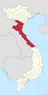
Mường Lát district
Appearance
(Redirected from Mường Lát District)
You can help expand this article with text translated from the corresponding article in Vietnamese. (March 2009) Click [show] for important translation instructions.
|
Mường Lát district
Huyện Mường Lát | |
|---|---|
 | |
| Country | |
| Region | North Central Coast |
| Province | Thanh Hóa |
| Established | November 18, 1996 |
| Capital | Mường Lát |
| Area | |
| • District | 312.99 sq mi (810.65 km2) |
| Population (2018) | |
| • District | 41,640 |
| • Density | 130/sq mi (51/km2) |
| • Urban | 7,084 |
| Time zone | UTC+7 (UTC + 7) |
Mường Lát is a district (huyện) of Thanh Hóa province in the North Central Coast region of Vietnam.
As of 2018, the district had a population of 41,640.[1] The district covers an area of 810.65 km². The district capital lies at Mường Lát town.[1]
Municipalities
[edit]| Name | Area (km²) | Population | Density (people/km2) | Statistical Years |
|---|---|---|---|---|
| Mường Lát (town) (District capital) | 129.66 | 7,084 | 55 | 2019 |
| Mường Chanh | 64.98 | 2,546 | 39 | 1999 |
| Mường Lý | 120.09 | 3,874 | 32 | 1999 |
| Nhi Sơn | 36.85 | 2,029 | 55 | 2008 |
| Pù Nhi | 67.55 | 3,754 | 56 | 2008 |
| Quang Chiểu | 108.75 | 4,343 | 40 | 1999 |
| Tam Chung | 121.98 | 1,622 | 13 | 2003 |
| Trung Lý | 162.3 | 4,263 | 26 | 1999 |
References
[edit]- ^ a b "Districts of Vietnam". Statoids. Retrieved March 19, 2009.

