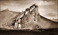
Kampa Dzong
Kampa
Kampa Dzong | |
|---|---|
 Kampa Dzong, Tibet 1904 | |
 |


Kampa or Kamba Dzong,[1][2][3][a] (Gampa Dzong in Standard Tibetan,[6][b] and Gangba Xian in Chinese)[c] is a Tibetan town north of Sikkim.[8] It is the headequarters Kamba County in the Shigatse Prefecture. It is marked by an iconic hill-top fort, much admired by the expeditions travelling to Mount Everest during the early 20th century. It also used to be a border trading post for Sikkimese traders from North Sikkim, prior to the Chinese annexation of Tibet.
History
[edit]Traditional Tibetan carpet making is thought[by whom?] to have originated in Kampa Dzong.[9]

In June 1903, Colonel Francis Younghusband, serving as British commissioner to Tibet, led a diplomatic mission consisting of five officers and five hundred troops to Kampa Dzong.[10] The objective of the mission was to meet Chinese and Tibetan representatives and discuss mutual non-aggression and trade agreements. After being kept waiting for five months before the Chinese and Tibetan representatives arrived, the mission was recalled.[11]
Sino-Indian relations
[edit]The Sino-Indian border along the Sikkim is well-defined by the 1890 Convention of Calcutta signed by Britain and China. Despite this, frenetic construction of border infrastructure and troop deployment has been witnessed along the border.[12] During the 2020–2021 China–India skirmishes, one of the first clashes was reported at the Naku La pass, where a scuffle broke out between the Chinese and Indian forces, resulting in injuries to eleven soldiers.[13][14] During the 12th round of disengagement talks, the commanders of the two sides agreed to establish a hotline between the PLA base at Kampa Dzong and the Indian Army base at Kongra La. It was meant to enhance ties between the two armies and maintain peace and tranquility along the border.[15]
Notes
[edit]References
[edit]- ^ Bell, Tibet Past and Present (1924), p. 66.
- ^ Lamb, Britain and Chinese Central Asia (1960), p. 156.
- ^ Chan, Victor (1994), Tibet Handbook, Chico, CA: Moon Publications, pp. 839–840 – via archive.org
- ^ Powers & Holzinger, History as Propaganda (2004), p. 79.
- ^ French, Younghusband (1994), p. 175.
- ^ Tibet 2002: A Year Book, Tibet Information Network, London, p. 145.
- ^ a b "Geographical names of Tibet AR (China): Tibet Autonomous Region". KNAB Place Name Database. Institute of the Estonian Language. 2018-06-03.
- ^ Sikkim: a traveller's guide, Volume 2001 by Arundhati Ray, Sujoy Das
- ^ Tibet handbook: with Bhutan, by Gyurme Dorje
- ^ History as propaganda: Tibetan exiles versus the People's Republic of China by John Powers, p. 80
- ^ The great game: on secret service in high Asia, by Peter Hopkirk, p 507
- ^ Kumar, Ankit (26 March 2021). "Exclusive: Satellite images show active Chinese posts near Sikkim's Naku La". India Today.
- ^ "Indian and Chinese soldiers injured in cross-border fistfight, says Delhi". The Guardian. Agence France-Presse. 11 May 2020. ISSN 0261-3077. Archived from the original on 12 May 2020. Retrieved 12 May 2020.
- ^ Sud, Vedika; Westcott, Ben (11 May 2020). "Chinese and Indian soldiers engage in 'aggressive' cross-border skirmish". CNN. Retrieved 12 May 2020.
- ^ Vasudeva, P. K. (15 August 2021), "A thaw in ties", The Statesman (Kolkata)
Bibliography
[edit]- Bell, Charles (1924), Tibet Past and Present (First ed.), Oxford University Press
- French, Patrick (1994), Younghusband: the Last Great Imperial Adventurer, London: HarperCollins, ISBN 0-00-637601-0 – via archive.org
- Lamb, Alastair (1960), Britain and Chinese Central Asia, Routledge & Kegal Paul – via archive.org
- Powers, John; Holzinger, Lutz (2004), History as Propaganda: Tibetan Exiles Versus the People's Republic of China, Oxford University Press, USA, ISBN 978-0-19-517426-7
External links
[edit]- An abbot on a mountain, The Telegraph (Calcutta), 20 January 2006.Archived 23 October 2012 at the Wayback Machine
- Tibet a Chronicle of Exploration
