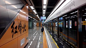
Hongling North station
Appearance
(Redirected from Hongling North Station)
 | ||||||||||||||||
| General information | ||||||||||||||||
| Location | Boundary between Luohu and Futian, Shenzhen, Guangdong China | |||||||||||||||
| Operated by | SZMC (Shenzhen Metro Group) | |||||||||||||||
| Line(s) | ||||||||||||||||
| History | ||||||||||||||||
| Opened | 28 October 2016 | |||||||||||||||
| Services | ||||||||||||||||
| ||||||||||||||||
Hongling North station (Chinese: 红岭北站; pinyin: Hónglǐng Běi Zhàn) is a station of Shenzhen Metro Line 7 and Line 9. It opened on 28 October 2016.[1]
Station layout
[edit]| G | - | Exit |
| B1F Concourse |
Lobby | Customer Service, Shops, Vending machines, ATMs |
| B2F Platforms |
Side platform, doors will open on the right | |
| Platform 1 | ← Line 9 towards Qianwan (Nigang) | |
| Side track | For trains of Line 9 | |
| Platform 2 | → Line 9 towards Wenjin (Yuanling) → | |
| Side platform, doors will open on the right | ||
| B3F Platforms |
Platform 3 | ← Line 7 towards Xili Lake (Bagualing) |
| Island platform, doors will open on the left | ||
| Platform 4 | → Line 7 towards Tai'an (Sungang) → | |
Exits
[edit]| Exit | Destination |
|---|---|
| Exit A | Bagua 4th Road, Shen'ai Building, Guangqian Industry District, Shenyao Building, Wanle Building, Rongsheng Building, Shenzhen No.4 People's Hospital (Futian Hospital ), Suotaike Building, Huachengda Building |
| Exit B | Zhongxin Technology Building, Bagua 3rd Road |
| Exit C | Reserved |
| Exit D | The first Inspection Department of Shenzhen Municipal Administration of Local Taxation, Taoyuan Commercial Building, East Side of Hongling North Road(S), South Side of Meiyuan Road, AKD Luxury Cars Mall, Jidian Building, Art Design Center |
| Exit E | Reserved |
| Exit F | |
| Exit G | North Side of Meiyuan Road, Art Design Center, Pearl Art Pacific, West Side of Liyuan Road |
| Exit H | Reserved |
| Exit J | East Side of Hongling North Road(N) |
References
[edit]External links
[edit]- Shenzhen Metro official page (Chinese)
- Shenzhen Metro official page (English)
- Street map
22°34′6″N 114°6′39″E / 22.56833°N 114.11083°E
