Haut-Lomami
Appearance
(Redirected from Haut-Lomami Province)
Haut-Lomami
| |
|---|---|
 | |
| Coordinates: 8°44′S 24°59′E / 8.733°S 24.983°E | |
| Country | |
| Established | 2015 |
| Named for | Lomami River |
| Capital | Kamina |
| Government | |
| • Governor | Marmont Banza[1] |
| Area | |
| • Total | 108,204 km2 (41,778 sq mi) |
| Population (2020 est.) | |
| • Total | 3,662,800 |
| • Density | 34/km2 (88/sq mi) |
| Time zone | UTC+2 (CAT) |
| License Plate Code | |
| Official language | French |
| National language | Swahili |
| Non-national language | Kiluba |
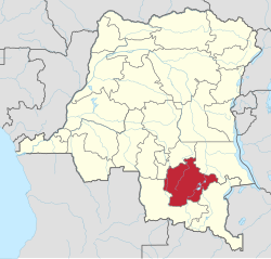
Haut-Lomami (French for "Upper Lomami") is one of the 21 provinces of the Democratic Republic of the Congo created in the 2015 repartitioning. Haut-Lomami, Haut-Katanga, Lualaba, and Tanganyika provinces are the result of the dismemberment of the former Katanga province.[2] Haut-Lomami was formed from the Haut-Lomami district whose town of Kamina was elevated to capital city of the new province.[3]
Territories
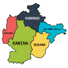
[edit]Haut-Lomami is divided into 5 territories.

See also
[edit]References
[edit]- ^ Lukusa, Patient (26 July 2024). "Haut-Lomami : le gouverneur Marmont Banza publie un gouvernement de 10 ministres dont 2 femmes". 7sur7.cd (in French). Retrieved 2 September 2024.
- ^ "Le Katanga officiellement démembré en quatre nouvelles provinces". Radio Okapi (in French). 16 July 2015. Archived from the original on 19 July 2015. Retrieved 8 June 2020.
- ^ "Provinces of the Democratic Republic of Congo". Statiods.com. Archived from the original on 2012-02-05. Retrieved 2012-01-24.
