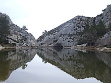
Glanum Dam
| Glanum Dam | |
|---|---|
 | |
| Location | Glanum (Saint-Rémy-de-Provence), Bouches-du-Rhône, France |
| Coordinates | 43°46′17″N 4°49′44″E / 43.77139°N 4.82889°E |
| Opening date | 1st century BC |
| Dam and spillways | |
| Impounds | Vallon de Baume |
| Height | 12 m |
| Length | 18 m |
| Width (base) | 3.9 m |
| Reservoir | |
| Creates | Lac des Peiròu |
The Glanum Dam, also known as the Vallon de Baume dam, was a Roman arch dam built to supply water to the Roman town of Glanum, the remains of which stand outside the town of Saint-Rémy-de-Provence in Southern France. It was situated south of Glanum, in a gorge that cut into the hills of the Alpilles in the Roman province of Gallia Narbonensis. Dating to the 1st century BC, it was the earliest known dam of its kind.[1] The remains of the dam were destroyed during the construction of a modern replacement in 1891, which now facilitates the supply of water to Saint-Rémy-de-Provence in the Bouches-du-Rhône region of France.[2]
The remains of the Roman dam at Glanum were discovered in 1763 by Esprit Calvet. A recent study[3] shows that the dam originally was composed of two curved parallel masonry walls, each around 1 metre (3.3 ft) thick and separated by a gap around 1.5 metres (4.9 ft) wide which was likely filled with earth and rubble.[2][4] The cut stone blocks were held together by crampons and finished with Cordon joints designed to protect against water entry. At each end of the dam there was an abutment cut into the rock of the gorge.[3] Overall the dam stood 6 metres (20 ft) high with a thickness of 3.5 metres (11 ft).
Its dimensions and location in a steep-sided gorge point towards it being a true arch dam. The dam collected water that was fed into an aqueduct that in turn supplied the Roman town of Glanum.[4]
A modern arched dam was constructed on the same site in 1891, destroying the remains of the Roman dam.[2][4] The dam's reservoir is called in French the Lac de Peirou and is accessible via the Chemin du Barrage.
See also
[edit]Notes
[edit]- ^ Smith 1971, pp. 33–35; Schnitter 1978, pp. 31f.; Schnitter 1987a, p. 12; Schnitter 1987b, p. 80; Hodge 2000, p. 332, fn. 2
- ^ a b c Hodge 2002, p. 81
- ^ a b James & Chanson 2002
- ^ a b c Hill 1996, p. 53
References
[edit]- James, Patrick; Chanson, Hubert (2002), "Historical Development of Arch Dams. From Roman Arch Dams to Modern Concrete Designs", Australian Civil Engineering Transactions, CE43: 39–56
- Hill, Donald (1996), A History of Engineering in Classical and Medieval Times, Routledge, p. 53
- Hodge, A. Trevor (2000), "Reservoirs and Dams", in Wikander, Örjan (ed.), Handbook of Ancient Water Technology, Technology and Change in History, vol. 2, Leiden: Brill, pp. 331–339, ISBN 90-04-11123-9
- Hodge, A. Trevor (2002), Roman Aqueducts & Water Supply, Duckworth, p. 81
- Schnitter, Niklaus (1978), "Römische Talsperren", Antike Welt, 8 (2): 25–32 (31f.)
- Schnitter, Niklaus (1987a), "Verzeichnis geschichtlicher Talsperren bis Ende des 17. Jahrhunderts", in Garbrecht, Günther (ed.), Historische Talsperren, Stuttgart: Verlag Konrad Wittwer, pp. 9–20, ISBN 3-87919-145-X
- Schnitter, Niklaus (1987b), "Die Entwicklungsgeschichte der Bogenstaumauer", in Garbrecht, Günther (ed.), Historische Talsperren, Stuttgart: Verlag Konrad Wittwer, pp. 75–96, ISBN 3-87919-145-X
- Smith, Norman (1971), A History of Dams, London: Peter Davies, ISBN 0-432-15090-0
Further reading
[edit]- Agusta-Boularot, S.; Paillet, J.L. (1997), "Le Barrage et l'Aqueduc Occidental de Glanum: le Premier Barrage-Voûte de l'Histoire des Techniques?", Revue Archéologique, 1: 27–78
- Benoit, Fernand (1935), "Le Barrage et l'Aqueduc Romains de Saint-Rémy de Provence", Revue des Études Anciennes, 37 (3): 331–340, doi:10.3406/rea.1935.2836
- 1763 archaeological discoveries
- 1891 disestablishments in France
- Buildings and structures demolished in 1891
- Dams in France
- Ancient Roman dams
- Arch dams
- Buildings and structures in Bouches-du-Rhône
- Roman sites in Provence
- 1st-century BC establishments in Roman Gaul
- Buildings and structures completed in the 1st century BC
- Gallia Narbonensis
- Demolished buildings and structures in France


