
File:Yangtze kiang 1915.jpg
Size of this preview: 800 × 151 pixels. Other resolutions: 320 × 60 pixels | 640 × 121 pixels | 1,024 × 193 pixels | 4,534 × 854 pixels.
Original file (4,534 × 854 pixels, file size: 560 KB, MIME type: image/jpeg)
| This is a file from the Wikimedia Commons. Information from its description page there is shown below. Commons is a freely licensed media file repository. You can help. |
Summary
| Description |
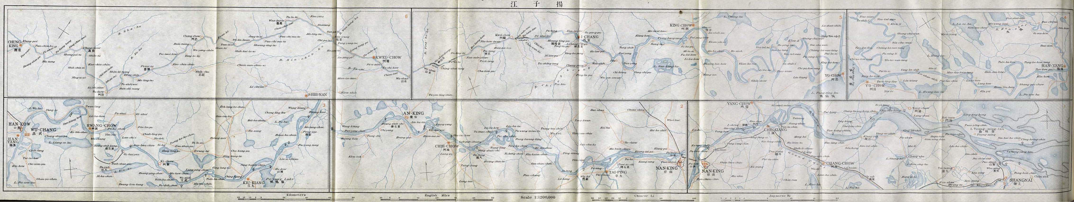
English: The map of the Yangtze Valey, scale 1;1,200,000. From An Official Guide to Eastern Asia, Volume IV: China. Published by The Imperial Japanese Government Railways. Tokyo, 1915. |
| Date | |
| Source | http://www.lib.utexas.edu/maps/historical/yangtze_kiang_1915.jpg in Perry-Castañeda Library Map Collection (http://www.lib.utexas.edu/maps/historical/history_china.html ) |
| Author | Compilers of " An Official Guide to Eastern Asia, Volume IV: China. Published by The Imperial Japanese Government Railways. Tokyo, 1915. " |
Licensing
|
This work is in the public domain in its country of origin and other countries and areas where the copyright term is the author's life plus 70 years or fewer. | |
| This file has been identified as being free of known restrictions under copyright law, including all related and neighboring rights. | |
File history
Click on a date/time to view the file as it appeared at that time.
| Date/Time | Thumbnail | Dimensions | User | Comment | |
|---|---|---|---|---|---|
| current | 23:52, 20 November 2008 | 4,534 × 854 (560 KB) | Vmenkov | {{Information |Description={{en|1=The map of the Yangtze Valey, scale 1;1,200,000. From An Offical Guide to Eastern Asia, Volume IV: China. Published by The Imperial Japanese Government Railways. Tokyo, 1915. }} |Source=http://www.lib.utexas.edu/maps/his |
File usage
The following pages on the English Wikipedia use this file (pages on other projects are not listed):