
File:Tasmanmap1644.jpg

Original file (3,236 × 2,516 pixels, file size: 2.83 MB, MIME type: image/jpeg)
| This is a file from the Wikimedia Commons. Information from its description page there is shown below. Commons is a freely licensed media file repository. You can help. |
Summary
| Description |
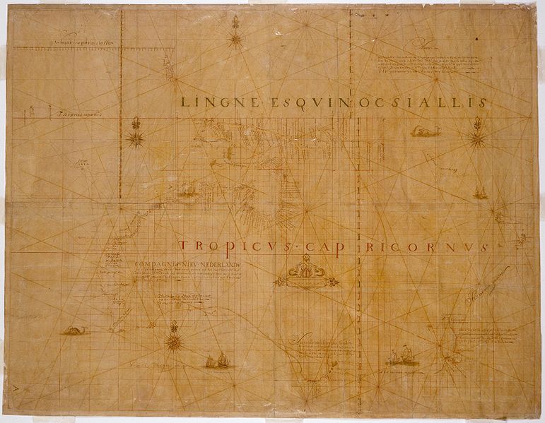
English: TitleCarten - Deze landen Zijn ontdeckt bij de compangie ontdeckers behaluen het norder deelt van noua guina ende het West Eynde van Java dit Warck aldus bij mallecanderen geuoecht ut verscheijden schriften als mede ut eijgen beuinding bij abel Jansen Tasman. Ano 1644 dat door order van de E.d.hr. gouuerneur general Anthonio van diemens Title translatedMap - These lands were discovered by the Company's explorers except for the northern part of New Guinea and the west end of Java. This work thus put together from different writings as well as from personal observation by Abel Jansen Tasman, A.D. 1644, by order of His Excellency the Governor-General Antonio van Diemen. Also known asBonaparte Tasman map; Tasman map 1644. Notes100 German or geographical miles on the graphic scale measures 6,8 cm.; 15 German miles equals one degree of latitude. Ornate manuscript map on Japanese paper bought in 1891 by Prince Roland Bonaparte, and presented to the Mitchell Library by the Princess George of Greece in 1931. Now thought to be neither by Tasman nor from 1644, this map is important for being the only first-hand record of Tasman's route in 1644. Includes inset with Mauritius, Java and Sumatra on scale ca. 1:21 568 600 showing the course of the Heemskerck and the Zeehaen in 1642 from Batavia to Mauritius and further south. Also available in a digitised form via the Internet at https://collection.sl.nsw.gov.au/record/74VvALr6N6VO This item has been included in the Nelson Meers Foundation Benefaction, 2003. |
| Source | State Library of New South Wales |
| Author | Unknown author |
Licensing
|
This work is in the public domain in its country of origin and other countries and areas where the copyright term is the author's life plus 70 years or fewer. | |
| This file has been identified as being free of known restrictions under copyright law, including all related and neighboring rights. | |
File history
Click on a date/time to view the file as it appeared at that time.
| Date/Time | Thumbnail | Dimensions | User | Comment | |
|---|---|---|---|---|---|
| current | 21:20, 6 January 2009 | | 3,236 × 2,516 (2.83 MB) | Gobeirne | crop black space further |
| 21:18, 6 January 2009 |  | 3,236 × 2,518 (2.82 MB) | Gobeirne | crop black space | |
| 15:53, 5 April 2006 |  | 4,000 × 3,000 (1.2 MB) | Harmsma~commonswiki | Title Carten dese landen Zin ontdeckt bij de compangie ontdeckers behaluen het norder deelt van noua guina ende het West Eynde van Java dit Warck aldus bij mallecanderen geuoecht ut verscheijden schriften als mede ut eijgen beuinding bij abel Jansen Tasm |
File usage
Global file usage
The following other wikis use this file:
- Usage on ast.wiki.x.io
- Usage on ca.wiki.x.io
- Usage on es.wiki.x.io
- Usage on fr.wiki.x.io
- Usage on it.wiki.x.io
- Usage on pl.wiki.x.io
- Usage on pt.wiki.x.io
- Usage on th.wiki.x.io
- Usage on uk.wiki.x.io
- Usage on vi.wiki.x.io
- Usage on www.wikidata.org
- Usage on zh.wiki.x.io