
File:Südostwall.jpg

Size of this preview: 537 × 599 pixels. Other resolutions: 215 × 240 pixels | 430 × 480 pixels | 688 × 768 pixels | 917 × 1,024 pixels | 1,835 × 2,048 pixels | 5,910 × 6,596 pixels.
Original file (5,910 × 6,596 pixels, file size: 12.83 MB, MIME type: image/jpeg)
| This is a file from the Wikimedia Commons. Information from its description page there is shown below. Commons is a freely licensed media file repository. You can help. |
Summary
| Description |
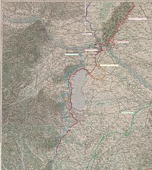
English: Fronline map ww2 marked in by myself on basis of a map from the 3rd Military Mapping Survey of Austria-Hungary |
| Date | The original sheets were published about 1910 |
| Source | http://lazarus.elte.hu/hun/digkonyv/topo/3felmeres.htm |
| Author | 3rd Military Mapping Survey of Austria-Hungary in 1910 |
Licensing
|
This work is in the public domain in its country of origin and other countries and areas where the copyright term is the author's life plus 70 years or fewer. | |
| This file has been identified as being free of known restrictions under copyright law, including all related and neighboring rights. | |
File history
Click on a date/time to view the file as it appeared at that time.
| Date/Time | Thumbnail | Dimensions | User | Comment | |
|---|---|---|---|---|---|
| current | 18:49, 28 September 2010 | | 5,910 × 6,596 (12.83 MB) | Mullerkingdom | {{Information |Description={{en|1=Fronline map ww2 marked in by myself on basis of a map from the 3rd Military Mapping Survey of Austria-Hungary}} |Source=http://lazarus.elte.hu/hun/digkonyv/topo/3felmeres.htm |Author=3rd Military Mapping Survey of Austri |
File usage
The following pages on the English Wikipedia use this file (pages on other projects are not listed):
Global file usage
The following other wikis use this file:
- Usage on de.wiki.x.io