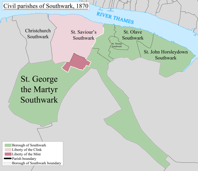
File:Southwark Civil Parish Map 1870.png
Appearance

Size of this preview: 697 × 600 pixels. Other resolutions: 279 × 240 pixels | 558 × 480 pixels | 893 × 768 pixels | 1,190 × 1,024 pixels | 2,380 × 2,048 pixels | 7,982 × 6,869 pixels.
Original file (7,982 × 6,869 pixels, file size: 2.63 MB, MIME type: image/png)
File history
Click on a date/time to view the file as it appeared at that time.
| Date/Time | Thumbnail | Dimensions | User | Comment | |
|---|---|---|---|---|---|
| current | 13:37, 21 February 2014 |  | 7,982 × 6,869 (2.63 MB) | Doc77can | User created page with UploadWizard |
File usage
The following 13 pages use this file:
- Liberty of the Clink
- Liberty of the Mint
- List of civil parishes in the City of London
- Southwark
- Southwark Christchurch
- Southwark St George the Martyr
- Southwark St John Horsleydown
- Southwark St Olave
- Southwark St Saviour
- St Olave District (Metropolis)
- St Saviour's District (Metropolis)
- St Thomas' Hospital
- User:Doc77can
Global file usage
The following other wikis use this file:
- Usage on de.wiki.x.io
- Usage on it.wiki.x.io
