
File:Seychelles-CIA WFB Map.png
No higher resolution available.
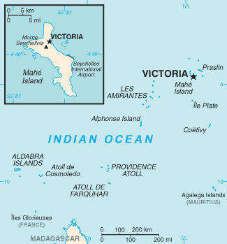
Seychelles-CIA_WFB_Map.png (325 × 349 pixels, file size: 9 KB, MIME type: image/png)
| This is a file from the Wikimedia Commons. Information from its description page there is shown below. Commons is a freely licensed media file repository. You can help. |
Summary
This image is in the public domain because it contains materials that originally came from the United States Central Intelligence Agency's World Factbook.
|
 |
File history
Click on a date/time to view the file as it appeared at that time.
| Date/Time | Thumbnail | Dimensions | User | Comment | |
|---|---|---|---|---|---|
| current | 05:01, 12 February 2022 | | 325 × 349 (9 KB) | Lojwe | Cropped 1 % horizontally, 1 % vertically using CropTool with precise mode. |
| 08:56, 17 February 2006 |  | 328 × 352 (9 KB) | Hoshie | Updated map of the Seychelles from the CIA World Factbook, 10 Jan 06 rev: http://www.cia.gov/cia/publications/factbook/maps/se-map.gif | |
| 09:17, 27 March 2005 |  | 328 × 353 (4 KB) | Wolfman~commonswiki | {{CIA-map}} |
File usage
The following pages on the English Wikipedia use this file (pages on other projects are not listed):
Global file usage
The following other wikis use this file:
- Usage on bn.wiki.x.io
- Usage on en.wikisource.org
- Usage on en.wiktionary.org
- Usage on es.wiki.x.io
- Usage on fa.wiki.x.io
- Usage on fi.wiki.x.io
- Usage on fr.wiki.x.io
- Usage on it.wiki.x.io
- Usage on lfn.wiki.x.io
- Usage on lt.wiktionary.org
- Usage on mdf.wiki.x.io
- Usage on nl.wiki.x.io
- Usage on nn.wiki.x.io
- Usage on pl.wiktionary.org
- Usage on sg.wiki.x.io
- Usage on sg.wiktionary.org
- Usage on tr.wiktionary.org
- Usage on zh.wiki.x.io
- Usage on zh.wiktionary.org