
File:SO GE large.JPG

Size of this preview: 800 × 548 pixels. Other resolutions: 320 × 219 pixels | 640 × 438 pixels | 1,024 × 701 pixels | 1,262 × 864 pixels.
Original file (1,262 × 864 pixels, file size: 484 KB, MIME type: image/jpeg)
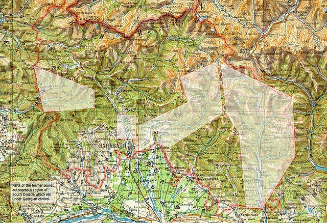
- Description: The picture shows parts of the former Soviet autonomous region of South Ossetia which are (supposedly) currently in Georgian control. The information is taken from a map published by the International Crisis Group.
- Source: The map was basically scanned from an old Soviet map. The rectangles representing the Georgian controlled areas were added via image editing software.
 | I, the creator of this work, hereby grant the permission to copy, distribute and/or modify this document under the terms of the GNU Free Documentation License, Version 1.2 or any later version published by the Free Software Foundation; with no Invariant Sections, no Front-Cover Texts, and no Back-Cover Texts. Subject to disclaimers. |
| This work is licensed under the Creative Commons Attribution-ShareAlike 3.0 License. This licensing tag was added to this file as part of the GFDL licensing update. |
| This media file is either in the public domain or published under a free license, and contains no inbound file links. If this media file is useful, then it should be transferred to the Wikimedia Commons. If this media is not useful, then please propose it for deletion or list it at files for discussion. |
 | This file is a candidate to be copied to Wikimedia Commons.
Any user may perform this transfer; refer to Wikipedia:Moving files to Commons for details. If this file has problems with attribution, copyright, or is otherwise ineligible for Commons, then remove this tag and DO NOT transfer it; repeat violators may be blocked from editing. Other Instructions
| ||
| |||
File history
Click on a date/time to view the file as it appeared at that time.
| Date/Time | Thumbnail | Dimensions | User | Comment | |
|---|---|---|---|---|---|
| current | 16:16, 27 January 2007 | | 1,262 × 864 (484 KB) | PMR-Tyras (talk | contribs) | *Description: The picture shows parts of the former Soviet autonomous region of South Ossetia which are (''supposedly'') currently in Georgian control. The information is taken from a [http://www.internal-displacement.org/8025708F004BE3B1/(httpInfoFiles)/ |
You cannot overwrite this file.
File usage
No pages on the English Wikipedia use this file (pages on other projects are not listed).