
File:Preciosa.jpg

Original file (4,160 × 2,336 pixels, file size: 2.9 MB, MIME type: image/jpeg)
| This is a file from the Wikimedia Commons. Information from its description page there is shown below. Commons is a freely licensed media file repository. You can help. |
Summary
| Description |
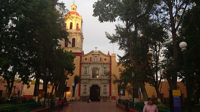
Español: Capilla de la Purísima Concepción
|
||
| Date | |||
| Source | Own work | ||
| Author | Dagojacy1 |
| Camera location | | View this and other nearby images on: OpenStreetMap |
|---|
Historia de la Parroquia de Santa María del Río El pueblo de Santa María del Río fue fundado, según versiones, el 15 de agosto de 1542 por el Cacique de Jilotepec, Juan de Santamaría, con cuarenta familias otomíes y 40 familias chichimecas, las que permanecieron en este lugar hasta 1589. Por temor a un levantamiento de los indígenas y sobre todo de los guachichiles, fueron trasladados por el capitán Gabriel Ortiz de Fuenmayor y su superior el Capitán Pedro de Anda al fuerte de Atotonilco, dos leguas delante de la estancia de D. José Villela, donde permanecieron 21 años hasta que éste se quejó ante el Virrey Don Luis de Velazco. Como era su costumbre en cada iglesia o capilla que levantaba, también aquí dono una imagen, en éste caso de la Virgen de la Asunción, por lo que se puede concluir que a él se debe el nombre de Santa María del Río, en honor a la imagen y del río, que dividía al cañón, y que los indígenas llamaban Alguaguaque. Desde su origen la parroquia perteneció al obispado de Michoacán hasta 1854 en que San Luis Potosí fue erigida diócesis. Desde en principio fue atendida por los padres franciscanos, que obedecían a los provinciales de Zacatecas. Sus antiguos curas se denominaban “lenguas”, porque para desempeñar ciertos oficios eclesiásticos tenían que hablar el idioma de sus feligreses. En el centro del poblado se encuentra la Capilla de la Purísima, que fue el primer templo construido a mitad del siglo XVII por los indios, bajo la dirección de los frailes franciscanos que habitaban en el convento. Mientras que el actual templo parroquial fue inagurado el 15 de agosto de 1845. El curato se terminó de construir en 1884 y la capilla del Santísimo se inició en 1838 y se terminó en 1880.
Licensing
- You are free:
- to share – to copy, distribute and transmit the work
- to remix – to adapt the work
- Under the following conditions:
- attribution – You must give appropriate credit, provide a link to the license, and indicate if changes were made. You may do so in any reasonable manner, but not in any way that suggests the licensor endorses you or your use.
- share alike – If you remix, transform, or build upon the material, you must distribute your contributions under the same or compatible license as the original.

|
This image was uploaded as part of Wiki Loves Monuments 2018.
|
 |
File history
Click on a date/time to view the file as it appeared at that time.
| Date/Time | Thumbnail | Dimensions | User | Comment | |
|---|---|---|---|---|---|
| current | 22:59, 19 September 2018 | | 4,160 × 2,336 (2.9 MB) | Dagojacy1 | User created page with UploadWizard |
File usage
The following page uses this file: