
File:New Hebrides Plate map-fr.png
No higher resolution available.
New_Hebrides_Plate_map-fr.png (424 × 284 pixels, file size: 128 KB, MIME type: image/png)
| This is a file from the Wikimedia Commons. Information from its description page there is shown below. Commons is a freely licensed media file repository. You can help. |
| Description |
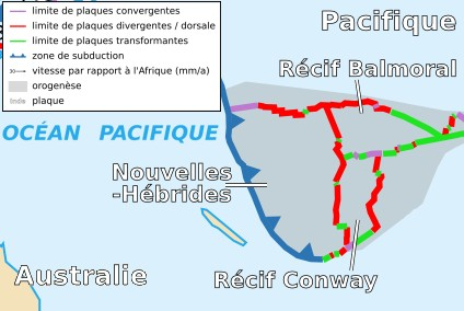
Français : Carte de la plaque des Nouvelles-Hébrides English: Map of the New-Hebrides Plate |
| Date | |
| Source | Cropped version by myself of Image:Tectonic_plates_boundaries_detailed-fr.svg created by Sting under CC-BY-SA |
| Author | Sting and Rémih |
| Permission (Reusing this file) |
This file is licensed under the Creative Commons Attribution-Share Alike 2.5 Generic license.
|
| Other versions |
Scaled version of  |
File history
Click on a date/time to view the file as it appeared at that time.
| Date/Time | Thumbnail | Dimensions | User | Comment | |
|---|---|---|---|---|---|
| current | 23:02, 18 November 2006 | | 424 × 284 (128 KB) | Rémih | {{Information |Description={{fr|Carte de la plaque des Nouvelles-Hébrides}}{{en|Map of the New-Hebrides Plate}} |Source=Cropped version by myself of Image:Tectonic_plates_boundaries_detailed-fr.svg created by Sting under CC-BY-SA |Dat |
File usage
The following 2 pages use this file:
Global file usage
The following other wikis use this file:
- Usage on az.wiki.x.io
- Usage on ca.wiki.x.io
- Usage on cs.wiki.x.io
- Usage on eu.wiki.x.io
- Usage on fa.wiki.x.io
- Usage on fr.wiki.x.io
- Usage on it.wiki.x.io
- Usage on ja.wiki.x.io
- Usage on ko.wiki.x.io
- Usage on mk.wiki.x.io
- Usage on pt.wiki.x.io
- Usage on ru.wiki.x.io
- Usage on uk.wiki.x.io
- Usage on www.wikidata.org
- Usage on zh.wiki.x.io