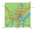
File:Mikkelin keskusta-alueen kartta.svg
Appearance

Size of this PNG preview of this SVG file: 628 × 599 pixels. Other resolutions: 251 × 240 pixels | 503 × 480 pixels | 805 × 768 pixels | 1,073 × 1,024 pixels | 2,146 × 2,048 pixels | 899 × 858 pixels.
Original file (SVG file, nominally 899 × 858 pixels, file size: 62 KB)
File history
Click on a date/time to view the file as it appeared at that time.
| Date/Time | Thumbnail | Dimensions | User | Comment | |
|---|---|---|---|---|---|
| current | 15:45, 17 December 2007 |  | 899 × 858 (62 KB) | Tsel~commonswiki | == Summary == {{Information |Description= {{fi|Mikkelin keskusta-alueen kartta, merkitty 1951 päätöksen mukaiset kaupunginosat}} {{en|Map of Mikkeli, neighbourhoods marked}} |Source=self-made |Date=2007-12-17 |Author= Taneli Selin |ot |
| 15:39, 17 December 2007 |  | 1,200 × 1,000 (65 KB) | Tsel~commonswiki | {{Information |Description= {{fi|Mikkelin keskusta-alueen kartta, merkitty 1951 päätöksen mukaiset kaupunginosat}} {{en|Map of Mikkeli, neighbourhoods marked}} |Source=self-made |Date=2007-12-17 |Author= Taneli Selin |other_versions= |
File usage
The following page uses this file:
Global file usage
The following other wikis use this file:
- Usage on ast.wiki.x.io
- Usage on es.wiki.x.io
- Usage on fi.wiki.x.io
- Usage on ja.wiki.x.io
- Usage on smn.wiki.x.io
