
File:Michigan Basin 2.jpg
Michigan_Basin_2.jpg (357 × 360 pixels, file size: 47 KB, MIME type: image/jpeg)
| This is a file from the Wikimedia Commons. Information from its description page there is shown below. Commons is a freely licensed media file repository. You can help. |
Summary
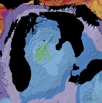
A geological map of the Michigan Basin.
Source: Michigan Basin archive copy at the Wayback Machine, The North American Tapestry of Time and Terrain, United States Department of the Interior. Text from this web page follows below.
A giant incomplete bull's-eye is centered on the state of Michigan. Radiating outward to Ohio, Indiana, Illinois, Wisconsin, and Ontario, this annular pattern outlines the Michigan Basin. The Basin is a bowl-shaped structure of uncertain origin that contains over 2.5 miles (4 km) of inward-dipping Paleozoic strata and a veneer of Jurassic sedimentary rocks. This curious basin is located in the less tectonically-active interior of the continent, bordered by the Appalachian and Rocky Mountains. It subsided rapidly from Cambrian to Silurian time and filled with shallow-water marine sediments, some of which contain deposits of petroleum, coal, and salt.
Licensing
This work is in the public domain in the United States because it is a work prepared by an officer or employee of the United States Government as part of that person’s official duties under the terms of Title 17, Chapter 1, Section 105 of the US Code.
Note: This only applies to original works of the Federal Government and not to the work of any individual U.S. state, territory, commonwealth, county, municipality, or any other subdivision. This template also does not apply to postage stamp designs published by the United States Postal Service since 1978. (See § 313.6(C)(1) of Compendium of U.S. Copyright Office Practices). It also does not apply to certain US coins; see The US Mint Terms of Use.
|
 | |
| This file has been identified as being free of known restrictions under copyright law, including all related and neighboring rights. | ||
File history
Click on a date/time to view the file as it appeared at that time.
| Date/Time | Thumbnail | Dimensions | User | Comment | |
|---|---|---|---|---|---|
| current | 11:29, 15 June 2007 | | 357 × 360 (47 KB) | Avenue | A geological map of the Michigan Basin. Source: [http://nationalatlas.gov/articles/geology/features/michiganbasin.html Michigan Basin], The North American Tapestry of Time and Terrain, United States Department of the Interior. Text from this web page fo |
File usage
Global file usage
The following other wikis use this file:
- Usage on ar.wiki.x.io
- Usage on en.wikibooks.org
- Usage on it.wiki.x.io
- Usage on ru.wiki.x.io
- Usage on sh.wiki.x.io
- Usage on sr.wiki.x.io
- Usage on sv.wiki.x.io
- Usage on www.wikidata.org