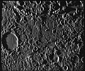
File:Mercury's 'Weird Terrain'.jpg
Appearance

Size of this preview: 713 × 600 pixels. Other resolutions: 285 × 240 pixels | 571 × 480 pixels | 832 × 700 pixels.
Original file (832 × 700 pixels, file size: 128 KB, MIME type: image/jpeg)
File history
Click on a date/time to view the file as it appeared at that time.
| Date/Time | Thumbnail | Dimensions | User | Comment | |
|---|---|---|---|---|---|
| current | 21:33, 21 January 2020 |  | 832 × 700 (128 KB) | Jstuby | Original higher-resolution image, but brightness and contrast adjusted to approximately match original upload. http://ser.sese.asu.edu/M10/IMAGE_ARCHIVE/SingleImage.html?image_number=27463 |
| 22:15, 5 January 2007 |  | 496 × 358 (63 KB) | Dronemvp~commonswiki | {{Information |Description=The so-called 'Weird terrain' on Mercury, at the antipodal point of the en:Caloris Basin. From http://pds.jpl.nasa.gov/planets/captions/mercury/mercter.htm. |Source=Originally from [http://en.wiki.x.io en.wikipedia]; d |
File usage
The following 4 pages use this file:
Global file usage
The following other wikis use this file:
- Usage on ar.wiki.x.io
- Usage on bn.wiki.x.io
- Usage on bo.wiki.x.io
- Usage on da.wiki.x.io
- Usage on en.wikiversity.org
- Usage on es.wiki.x.io
- Usage on fa.wiki.x.io
- Usage on fr.wiki.x.io
- Usage on gl.wiki.x.io
- Usage on he.wiki.x.io
- Usage on hu.wiki.x.io
- Usage on it.wiki.x.io
- Usage on ja.wiki.x.io
- Usage on kn.wiki.x.io
- Usage on ko.wiki.x.io
- Usage on la.wiki.x.io
- Usage on mk.wiki.x.io
- Usage on ml.wiki.x.io
- Usage on no.wiki.x.io
- Usage on pt.wiki.x.io
- Usage on ro.wiki.x.io
- Usage on ru.wiki.x.io
- Usage on sl.wiki.x.io
- Usage on sv.wiki.x.io
- Usage on uk.wiki.x.io
- Usage on vi.wiki.x.io
- Usage on zh.wiki.x.io


