
File:Map of Ukraine political simple Oblast Chmelnyzkyj.png

Size of this preview: 800 × 567 pixels. Other resolutions: 320 × 227 pixels | 640 × 454 pixels | 1,024 × 726 pixels | 1,280 × 908 pixels | 2,466 × 1,749 pixels.
Original file (2,466 × 1,749 pixels, file size: 204 KB, MIME type: image/png)
| This is a file from the Wikimedia Commons. Information from its description page there is shown below. Commons is a freely licensed media file repository. You can help. |
Summary
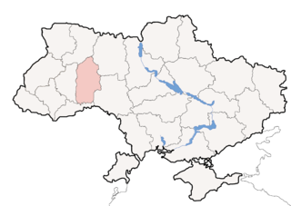
| Description | Political map of Ukraine, highlighting Khmelnitsky Oblast | ||||||
| Date | |||||||
| Source | Image (Map) made by Sven Teschke, Germany --Steschke 21:10, 6 Nov 2004 (UTC) | ||||||
| Author | Sven Teschke | ||||||
| Other versions |
[]
|


Licensing

|
Permission is granted to copy, distribute and/or modify this document under the terms of the GNU Free Documentation License, Version 1.2 or any later version published by the Free Software Foundation; with no Invariant Sections, no Front-Cover Texts, and no Back-Cover Texts. A copy of the license is included in the section entitled GNU Free Documentation License. |
| This file is licensed under the Creative Commons Attribution-Share Alike 3.0 Unported license. | ||
| ||
| This licensing tag was added to this file as part of the GFDL licensing update. |
This file is licensed under the Creative Commons Attribution-Share Alike 1.0 Generic license.
- You are free:
- to share – to copy, distribute and transmit the work
- to remix – to adapt the work
- Under the following conditions:
- attribution – You must give appropriate credit, provide a link to the license, and indicate if changes were made. You may do so in any reasonable manner, but not in any way that suggests the licensor endorses you or your use.
- share alike – If you alter, transform, or build upon this work, you must distribute the resulting work under the same license as the original.
File history
Click on a date/time to view the file as it appeared at that time.
| Date/Time | Thumbnail | Dimensions | User | Comment | |
|---|---|---|---|---|---|
| current | 16:13, 20 October 2014 | | 2,466 × 1,749 (204 KB) | Andrew J.Kurbiko | pp |
| 23:51, 5 May 2012 |  | 2,466 × 1,749 (283 KB) | An678ko | redesigned by Aplusc Studio | |
| 14:37, 30 November 2004 |  | 1,181 × 825 (16 KB) | Ed g2s | Simplified, compressed. | |
| 14:58, 7 November 2004 |  | 709 × 495 (195 KB) | Steschke | ukrainian oblast |
File usage
The following pages on the English Wikipedia use this file (pages on other projects are not listed):
Global file usage
The following other wikis use this file:
- Usage on avk.wiki.x.io
- Usage on be.wiki.x.io
- Usage on bs.wiki.x.io
- Usage on ceb.wiki.x.io
- Usage on cs.wiki.x.io
- Usage on de.wiki.x.io
- Usage on eo.wiki.x.io
- Usage on es.wiki.x.io
- Raión de Bilohiria
- Raión de Vinkivtsi
- Raión de Volochysk
- Raión de Gorodok (Jmelnitski)
- Raión de Derazhnia
- Raión de Dunaivtsi
- Raión de Iziaslav
- Raión de Kamianets-Podilski
- Raión de Krasyliv
- Raión de Letychiv
- Raión de Nova Ushytsia
- Raión de Polonne
- Raión de Slavuta
- Raión de Starokostiantyniv
- Raión de Stara Syniava
- Raión de Teofipol
- Raión de Jmelnitski
- Raión de Chemerivtsi
- Raión de Shepetivka
- Raión de Yarmolyntsi
- Usage on eu.wiki.x.io
- Usage on fa.wiki.x.io
- Usage on fi.wiki.x.io
- Usage on hr.wiki.x.io
- Usage on hu.wiki.x.io
- Usage on hy.wiki.x.io
- Usage on ka.wiki.x.io
- Usage on ko.wiki.x.io
- Usage on lt.wiki.x.io
- Usage on mdf.wiki.x.io
- Usage on mk.wiki.x.io
- Usage on ml.wiki.x.io
- Usage on mr.wiki.x.io
- Usage on myv.wiki.x.io
- Usage on nn.wiki.x.io
View more global usage of this file.