
File:Map of Poland and Lithuania in 1600.svg

Size of this PNG preview of this SVG file: 793 × 600 pixels. Other resolutions: 318 × 240 pixels | 635 × 480 pixels | 1,016 × 768 pixels | 1,280 × 968 pixels | 2,560 × 1,936 pixels | 845 × 639 pixels.
Original file (SVG file, nominally 845 × 639 pixels, file size: 48 KB)
| This is a file from the Wikimedia Commons. Information from its description page there is shown below. Commons is a freely licensed media file repository. You can help. |
| Description |
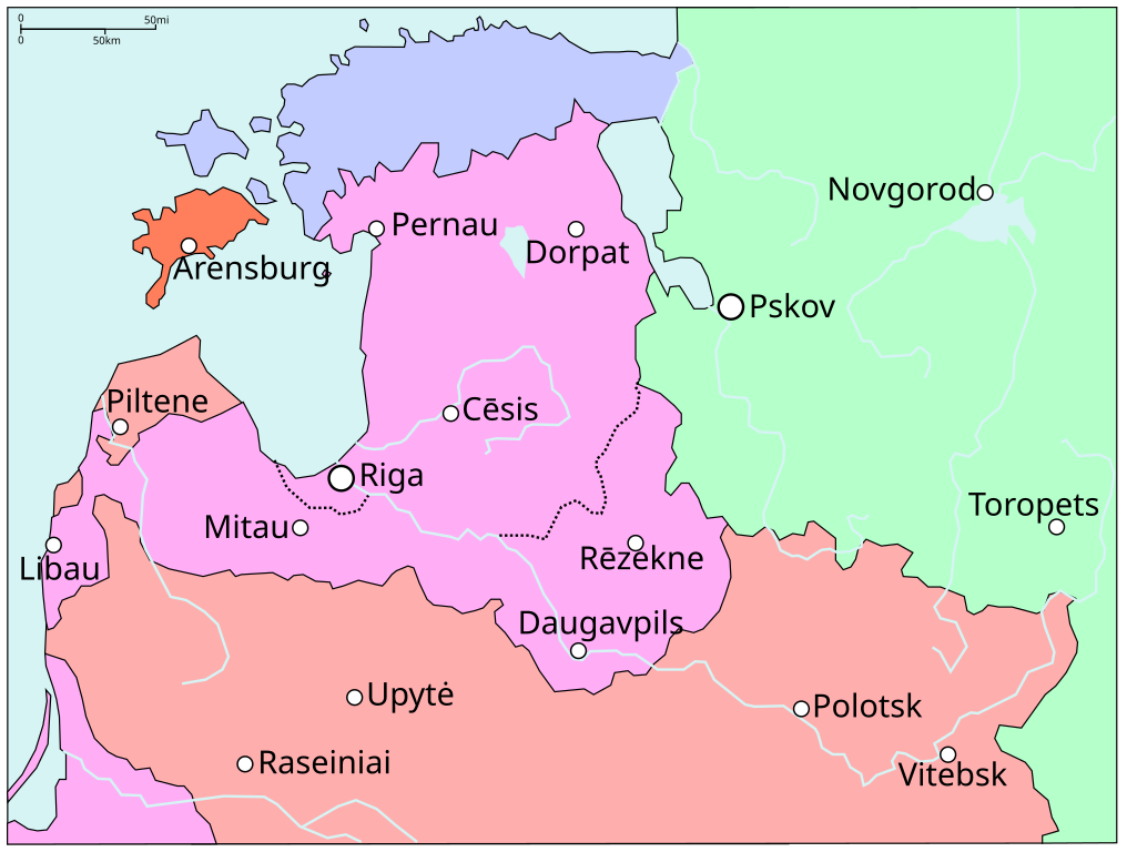
Map extract showing the status of Livonia in around 1600, before the Truce of Deulino. Compare with File:Map of Poland and Lithuania after the Union of Lublin (1569).svg.
|
| Date | (UTC) |
| Source | |
| Author |
|
| Other versions | Derivative works of this file: Livonian war map (1570-1577).svg |
.svg)
.svg)
| File | Type | Details |
|---|---|---|
| File:Polish-Lithuania map (1450-1600).svg | Large SVG | Map showing conflicts and territorial changes on the Polish-Lithuanian—Russian border, 1450–1600 |
| File:Duchy of Prussia.svg | Small SVG | Map of the Duchy of Prussia |
| File:Livonian war map (1558-1560).svg | Small SVG | Map showing campaigns in Livonia, 1558–1560. |
| File:Map of Poland and Lithuania after the Union of Lublin (1569).svg | Large SVG | Map of the w:Polish-Lithuanian Commonwealth after the Union of Lublin in 1569. |
| File:Livonian war map (1570-1577).svg | Small SVG | Map showing areas of Russian and Polish-Lithuanian forces, 1570–1577. |
| File:Campaigns of Stefan Batory.svg | Small SVG | Map of the campaign of Stefan Batory in Livonia (1575–1580). |
| File:Map of Poland and Lithuania in 1600.svg | Small SVG | Map of Livonia in 1600 |
| See also: User:Halibutt/maps, by Halibutt (talk · contribs). | ||
.svg)
.svg)
I, the copyright holder of this work, hereby publish it under the following licenses:
| This file is licensed under the Creative Commons Attribution-Share Alike 3.0 Unported license. | ||
| ||
| This licensing tag was added to this file as part of the GFDL licensing update. |

|
Permission is granted to copy, distribute and/or modify this document under the terms of the GNU Free Documentation License, Version 1.2 or any later version published by the Free Software Foundation; with no Invariant Sections, no Front-Cover Texts, and no Back-Cover Texts. A copy of the license is included in the section entitled GNU Free Documentation License. |
You may select the license of your choice.
Original upload log
This image is a derivative work of the following images:
- File:Rzeczpospolita_1600.png licensed with Cc-by-sa-3.0-migrated, GFDL
- 2010-02-24T13:36:04Z Dcoetzee 2000x1568 (326898 Bytes) Remove watermark, PNGcrush
- 2005-07-31T20:45:11Z Halibutt 2000x1568 (504471 Bytes) Commonwealth of Both Nations at the peak of its strength, after the Treaty of Dywilino. {{User:Halibutt/maps}} {{User:Halibutt/GFDL}} [[Category:Historical maps of Poland]] [[Category:Historical maps of Ukraine]] [[Catego
Uploaded with derivativeFX
File history
Click on a date/time to view the file as it appeared at that time.
| Date/Time | Thumbnail | Dimensions | User | Comment | |
|---|---|---|---|---|---|
| current | 11:08, 22 April 2011 | | 845 × 639 (48 KB) | Grandiose | Restore cities |
| 10:22, 22 April 2011 |  | 845 × 639 (48 KB) | Grandiose | Various fixes, inc. Estonian coastline. | |
| 09:59, 22 April 2011 |  | 845 × 639 (47 KB) | Grandiose | Optimise | |
| 17:19, 14 April 2011 |  | 845 × 639 (138 KB) | Grandiose | Various: colour scheme, text size, borders. | |
| 16:55, 14 April 2011 |  | 833 × 625 (135 KB) | Grandiose | {{Information |Description=Map extract showing the status of Livonia in around 1600, before the Truce of Deulino. Compare with File:Map of Poland and Lithuania after the Union of Lublin (1569).svg. |Source=*File:Rzeczpospolita_1600.png |Date=20 |
.svg)
File usage
The following pages on the English Wikipedia use this file (pages on other projects are not listed):
Global file usage
The following other wikis use this file:
- Usage on azb.wiki.x.io
- Usage on az.wiki.x.io
- Usage on cs.wiki.x.io
- Usage on da.wiki.x.io
- Usage on de.wiki.x.io
- Usage on es.wiki.x.io
- Usage on et.wiki.x.io
- Usage on fa.wiki.x.io
- Usage on fr.wiki.x.io
- Usage on it.wiki.x.io
- Usage on lt.wiki.x.io
- Usage on lv.wiki.x.io
- Usage on ro.wiki.x.io
- Usage on sl.wiki.x.io