
File:Map of Demerara, 1759.jpg

Size of this preview: 800 × 398 pixels. Other resolutions: 320 × 159 pixels | 640 × 318 pixels | 1,024 × 509 pixels | 1,280 × 636 pixels | 2,560 × 1,273 pixels | 5,500 × 2,734 pixels.
Original file (5,500 × 2,734 pixels, file size: 1.26 MB, MIME type: image/jpeg)
| This is a file from the Wikimedia Commons. Information from its description page there is shown below. Commons is a freely licensed media file repository. You can help. |
Summary
| Description |
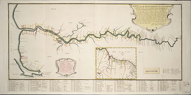
Nederlands: Caerte van de Rivier Demerary van ouds Immenary, geleger op Suyd Americaes Noordkust, op de Noorder Breedte van 6 Gr. 40
Zoom into this map at maps.bpl.org. Publisher: Leth, Henderick de Date: 1759 Location: Demerara River (Guyana) Dimension 44x100cm Scale: ca. 1:162,400 Call Number: G5252.D4 1759 .C34x |
| Date | |
| Source |
|
| Author | http://maps.bpl.org |
Licensing
This file is licensed under the Creative Commons Attribution 2.0 Generic license.
- You are free:
- to share – to copy, distribute and transmit the work
- to remix – to adapt the work
- Under the following conditions:
- attribution – You must give appropriate credit, provide a link to the license, and indicate if changes were made. You may do so in any reasonable manner, but not in any way that suggests the licensor endorses you or your use.
| This image, originally posted to Flickr, was reviewed on February 8, 2011 by the administrator or reviewer File Upload Bot (Magnus Manske), who confirmed that it was available on Flickr under the stated license on that date. |
File history
Click on a date/time to view the file as it appeared at that time.
| Date/Time | Thumbnail | Dimensions | User | Comment | |
|---|---|---|---|---|---|
| current | 22:52, 14 February 2011 | | 5,500 × 2,734 (1.26 MB) | Fentener van Vlissingen | higher res, source: http://www.geheugenvannederland.nl/?/nl/items/SURI01:KAARTENZL-25-20-01/&p=4&i=17&st=Suriname%20in%20kaart%20gebracht&sc=(isPartOf%20any%20'SURI01')/ |
| 02:40, 8 February 2011 |  | 2,000 × 1,015 (1.55 MB) | File Upload Bot (Magnus Manske) | {{Information |Description=Zoom into [http://maps.bpl.org/id/14290 this map] at [http://maps.bpl.org maps.bpl.org]. Publisher: Leth, Henderick de Date: 1759 Location: Demerara River (Guyana) Dimension 44x100cm Scale: ca. 1:162,400 Call Number: G5252.D4 |
File usage
The following 2 pages use this file:
Global file usage
The following other wikis use this file:
- Usage on ar.wiki.x.io
- Usage on ca.wiki.x.io
- Usage on fi.wiki.x.io
- Usage on it.wiki.x.io
- Usage on ja.wiki.x.io
- Usage on mt.wiki.x.io
- Usage on pl.wiki.x.io
- Usage on ru.wiki.x.io
- Usage on sl.wiki.x.io
- Usage on uk.wiki.x.io
- Usage on www.wikidata.org