
File:MGRSgridHawaiiSchemeAARealigned.png

Size of this preview: 800 × 512 pixels. Other resolutions: 320 × 205 pixels | 640 × 409 pixels | 991 × 634 pixels.
Original file (991 × 634 pixels, file size: 122 KB, MIME type: image/png)
| This is a file from the Wikimedia Commons. Information from its description page there is shown below. Commons is a freely licensed media file repository. You can help. |
| Description |
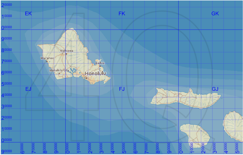
English: Map of the Military Grid Reference System (MGRS) around Hawaii, with the AA lettering scheme for the 100 km squares. This scheme is used for WGS 84 and some other modern geodetic datums, while the alternative AL lettering scheme is used for some older geodetic datums. |
| Date | |
| Source |
Improved version of File:MGRSgridHawaiiSchemeAA.png. The numeric labels for the vertical lines have been better aligned. Mikael R made the MGRS grid in Carmenta Engine, with a background map from Natural Earth by Tom Patterson, US National Park Service, and city names from geonames.org. |
| Author | Mikael Rittri |
| Permission (Reusing this file) |
This file is licensed under the Creative Commons Attribution-Share Alike 3.0 Unported license.
|
| Other versions |
 |
File history
Click on a date/time to view the file as it appeared at that time.
| Date/Time | Thumbnail | Dimensions | User | Comment | |
|---|---|---|---|---|---|
| current | 08:44, 25 September 2010 | | 991 × 634 (122 KB) | Mikrit~commonswiki | {{Information |Description={{en|1=Map of the Military Grid Reference System (MGRS) around Hawaii, with the AA lettering scheme for the 100 km squares. This scheme is used for WGS 84 and some other modern geodetic datums, while the alternative AL lettering |
File usage
The following page uses this file:
Global file usage
The following other wikis use this file:
- Usage on zh.wiki.x.io