
File:Limpopo 2011 population density map.svg

Size of this PNG preview of this SVG file: 800 × 530 pixels. Other resolutions: 320 × 212 pixels | 640 × 424 pixels | 1,024 × 679 pixels | 1,280 × 848 pixels | 2,560 × 1,697 pixels | 1,228 × 814 pixels.
Original file (SVG file, nominally 1,228 × 814 pixels, file size: 2.7 MB)
| This is a file from the Wikimedia Commons. Information from its description page there is shown below. Commons is a freely licensed media file repository. You can help. |
Summary
| Description |
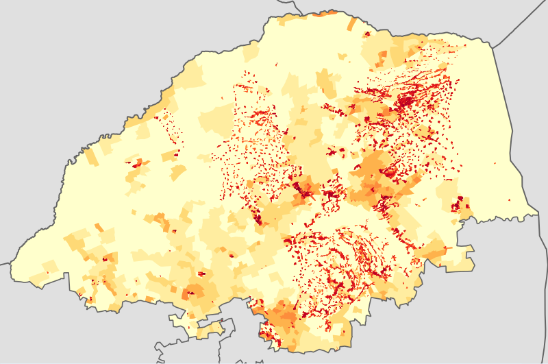
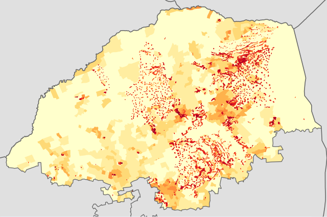
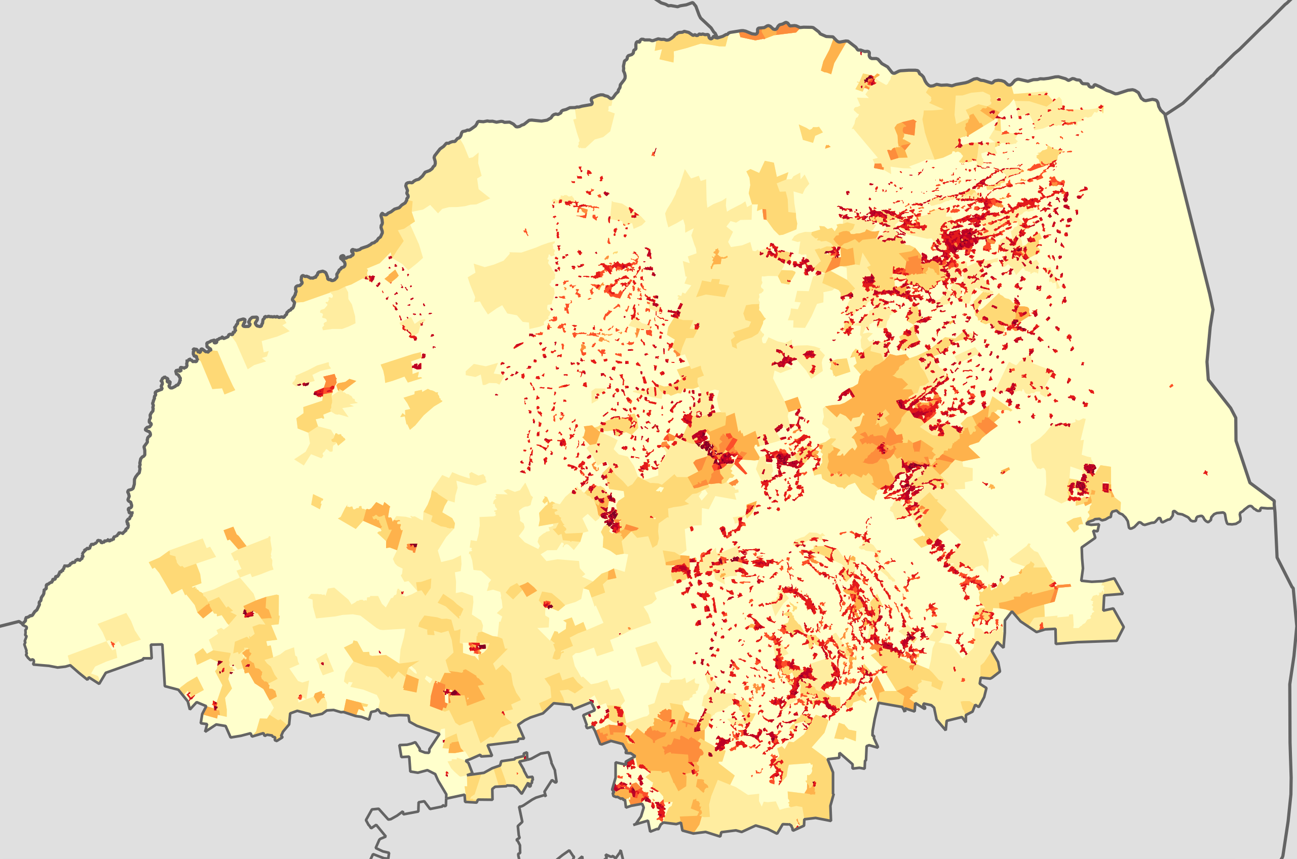
English: Population density map of Limpopo province of South Africa, from the 2011 Census, at the "Small Area" level.
<1 inhabitant/km²
1–3 inhabitants/km²
3–10 inhabitants/km²
10–30 inhabitants/km²
30–100 inhabitants/km²
100–300 inhabitants/km²
300–1000 inhabitants/km²
1000–3000 inhabitants/km²
>3000 inhabitants/km²
Projection is Albers Equal-Area Conic, with standard parallels at 25.5° S and 31.5° S, and origin at 28.5° S 25.5° E. |
| Date | |
| Source | Statistics South Africa's Census 2011 is the source of the basic population data. The map results from my own processing of the data. |
| Author | Htonl |
| Permission (Reusing this file) |
http://beta2.statssa.gov.za/?page_id=425 |
Licensing
The following license applies to the population data on which the map is based:

|
The copyright holder of this file, Statistics South Africa (States SA), allows anyone to use it for any purpose, provided that the copyright holder is properly attributed. Redistribution, derivative work, commercial use, and all other use is permitted. |
Attribution:
Statistics South Africa (States SA)
|
The following tag applies to the map itself:
| I, the copyright holder of this work, release this work into the public domain. This applies worldwide. In some countries this may not be legally possible; if so: I grant anyone the right to use this work for any purpose, without any conditions, unless such conditions are required by law. |
File history
Click on a date/time to view the file as it appeared at that time.
| Date/Time | Thumbnail | Dimensions | User | Comment | |
|---|---|---|---|---|---|
| current | 18:32, 22 October 2013 | | 1,228 × 814 (2.7 MB) | Htonl | == {{int:filedesc}} == {{Information |Description={{en|1=Population density map of Limpopo province of South Africa, from the 2011 Census, at the "Small Area" level. {{legend|#ffffcc|<1 inhabitant/km²}} {{legend|#ffeda0|1–3 inhabitants/km²}} {{l... |
File usage
The following pages on the English Wikipedia use this file (pages on other projects are not listed):
Global file usage
The following other wikis use this file:
- Usage on ca.wiki.x.io
- Usage on he.wiki.x.io
- Usage on hy.wiki.x.io
- Usage on ka.wiki.x.io
- Usage on nso.wiki.x.io
- Usage on ru.wiki.x.io