
File:Koppen-Geiger Map GEO present.svg

Size of this PNG preview of this SVG file: 800 × 374 pixels. Other resolutions: 320 × 150 pixels | 640 × 300 pixels | 1,024 × 479 pixels | 1,280 × 599 pixels | 2,560 × 1,198 pixels | 1,816 × 850 pixels.
Original file (SVG file, nominally 1,816 × 850 pixels, file size: 735 KB)
| This is a file from the Wikimedia Commons. Information from its description page there is shown below. Commons is a freely licensed media file repository. You can help. |
Summary
| Description |
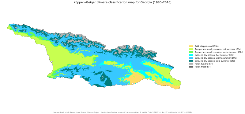
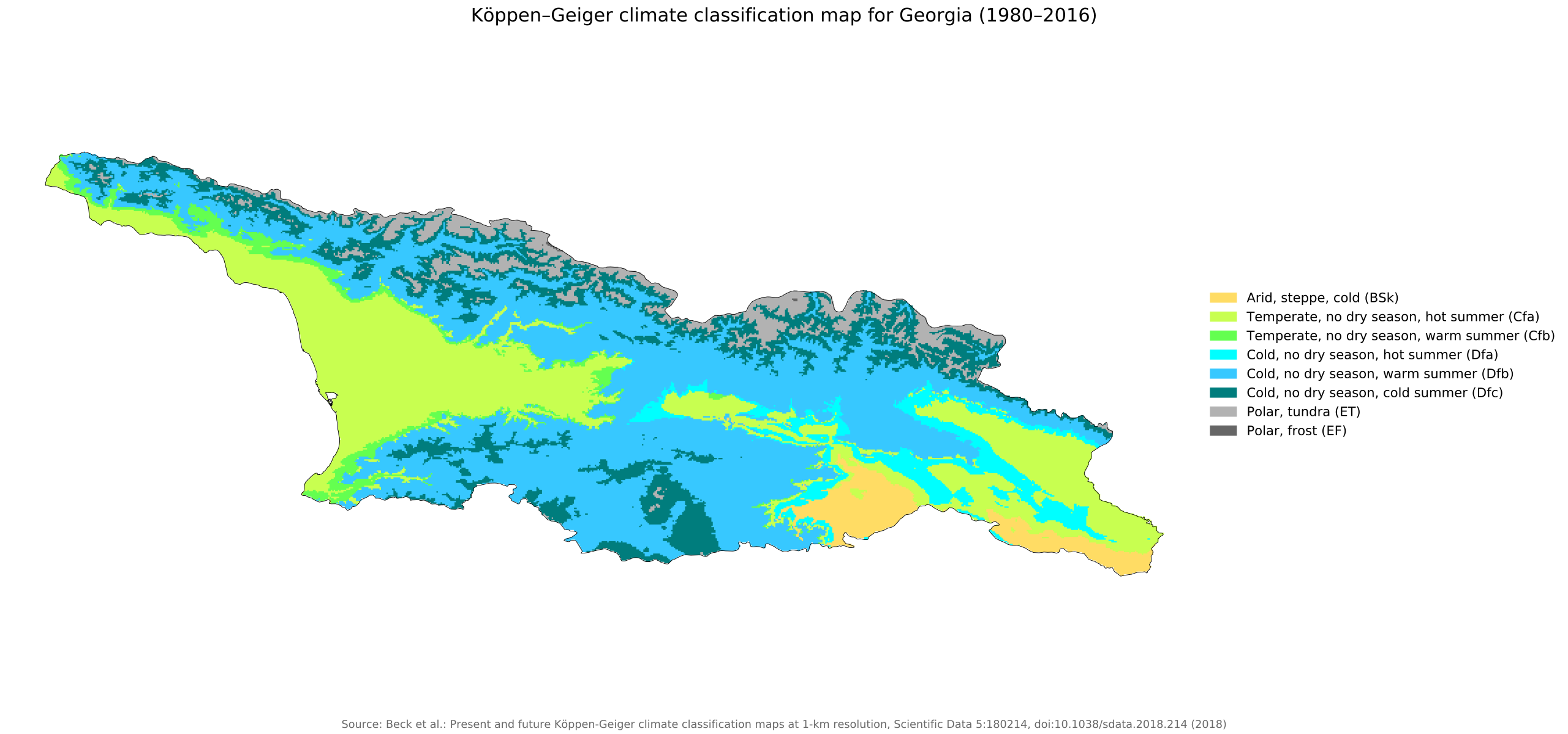
English: Köppen–Geiger climate classification map for Georgia |
| Date | |
| Source | "Present and future Köppen-Geiger climate classification maps at 1-km resolution". Nature Scientific Data. DOI:10.1038/sdata.2018.214. |
| Author | Beck, H.E., Zimmermann, N. E., McVicar, T. R., Vergopolan, N., Berg, A., & Wood, E. F. |
Licensing
This file is licensed under the Creative Commons Attribution 4.0 International license.
- You are free:
- to share – to copy, distribute and transmit the work
- to remix – to adapt the work
- Under the following conditions:
- attribution – You must give appropriate credit, provide a link to the license, and indicate if changes were made. You may do so in any reasonable manner, but not in any way that suggests the licensor endorses you or your use.
| Camera location | | View this and other nearby images on: OpenStreetMap |
|---|
File history
Click on a date/time to view the file as it appeared at that time.
| Date/Time | Thumbnail | Dimensions | User | Comment | |
|---|---|---|---|---|---|
| current | 04:50, 26 November 2018 | | 1,816 × 850 (735 KB) | NVergopolan | {{Information |Description={{en| Köppen–Geiger climate classification map for Georgia}}|date=2018-11-06|source={{cite journal | title=Present and future Köppen-Geiger climate classification maps at 1-km resolution | journal=Nature Scientific Data |doi=10.1038/sdata.2018.214}}|author=Beck, H.E., Zimmermann, N. E., McVicar, T. R., Vergopolan, N., Berg, A., & Wood, E. F.|permission=|other_versions=|other_fields=}}{{Cc-by-4.0}}{{Location|42.31152725|43.366233825}}[[Category:Köppen-Geiger Climate... |
File usage
The following 2 pages use this file:
Global file usage
The following other wikis use this file:
- Usage on ar.wiki.x.io
- Usage on da.wiki.x.io
- Usage on el.wiki.x.io
- Usage on id.wiki.x.io
- Usage on lt.wiki.x.io
- Usage on mk.wiki.x.io
- Usage on mt.wiki.x.io
- Usage on nl.wiki.x.io
- Usage on pl.wiki.x.io
- Usage on ro.wiki.x.io
- Usage on sl.wiki.x.io
- Usage on tr.wiki.x.io