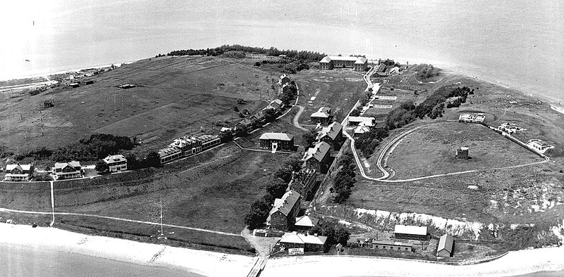
English: A 1932 Army photo of
Fort Andrews .The file of this image, acquired from the National Archives by the Coast Defense Study Group (CDSG) and distributed by them on disk, is entitled with the year 1932. It was made by the U.S. Army, and is stunning in its detail. It looks northwesterly. [The photo has been adjusted, sharpened, and cropped by the contributor.]
At center is the row of barracks buildings, with the second nearest one having already been gutted by fire. The wharf at bottom is in almost the same location as the current (2011) one.
At right are the three concrete gun batteries: Btty Rice (never armed) at top, Btty McCook (2 6-inch guns M1900), and Btty Bumpus (2 3-inch guns) at the extreme right edge of the photo. The small, light-colored oblong (with a small path running from Btty Rice toward it) northerly of Btty Rice is likely the searchlight position, whose remains can be seen today.
The starkly visible building with the shiny concrete roof in the middle of the area immediately behind the batteries is the 1904 fire control structure. This would have made an obvious target for any attacking ship.
The two mortar pits of Btty Cushing are visible at top along the road past the four barracks buildings. The other two pits (of Btty Whitman) are concealed behind the high berm at the top of photo.
The largest building in the curved line of structures at left is the base hospital. The buildings next to it closer to the camera are some of the officers' quarters, and those past the hospital are NCO quarters.
Atop the ridge on the left can be seen (from the left) the fort's radio station (with two tall antenna towers showing) quarters and a latrine for fire control personnel (toward the backside of the ridge), and the old fire control structure for the mortar batteries, a cemesto building built within a sunken pit with a half-story observation room on top of it.
The remarkable thing about this photo is how bare the fort looked in 1932. Today, it is mostly covered with thick woods and heavy brush, so that (for example) the surrounding waters are not even visible from the former fire control positions on the western ridge.


