
File:Former railway station, Ballynahinch - geograph.org.uk - 2831059.jpg
No higher resolution available.
Former_railway_station,_Ballynahinch_-_geograph.org.uk_-_2831059.jpg (640 × 375 pixels, file size: 103 KB, MIME type: image/jpeg)
| This is a file from the Wikimedia Commons. Information from its description page there is shown below. Commons is a freely licensed media file repository. You can help. |
Summary
| Description |
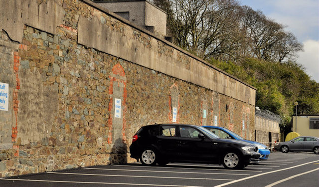
English: Former railway station, Ballynahinch. The site of the railway yard is now the Ulsterbus depot 2830935. The former station building and goods shed (left) have since been converted to a library and health centre. |
| Date | |
| Source | From geograph.org.uk; transferred by User:andrewrabbott using geograph_org2commons. |
| Author | Albert Bridge |
| Permission (Reusing this file) |
Creative Commons Attribution Share-alike license 2.0 |
| Attribution (required by the license) | Albert Bridge / Former railway station, Ballynahinch / |
_-_geograph.org.uk_-_2830935.jpg)
| Camera location | | View this and other nearby images on: OpenStreetMap |
|---|
| Object location | | View this and other nearby images on: OpenStreetMap |
|---|
_region:GB-NIR_heading:337.00&language=en)
Licensing

|
This image was taken from the Geograph project collection. See this photograph's page on the Geograph website for the photographer's contact details. The copyright on this image is owned by Albert Bridge and is licensed for reuse under the Creative Commons Attribution-ShareAlike 2.0 license.
|
This file is licensed under the Creative Commons Attribution-Share Alike 2.0 Generic license.
Attribution: Albert Bridge
- You are free:
- to share – to copy, distribute and transmit the work
- to remix – to adapt the work
- Under the following conditions:
- attribution – You must give appropriate credit, provide a link to the license, and indicate if changes were made. You may do so in any reasonable manner, but not in any way that suggests the licensor endorses you or your use.
- share alike – If you remix, transform, or build upon the material, you must distribute your contributions under the same or compatible license as the original.
File history
Click on a date/time to view the file as it appeared at that time.
| Date/Time | Thumbnail | Dimensions | User | Comment | |
|---|---|---|---|---|---|
| current | 16:49, 27 April 2012 | | 640 × 375 (103 KB) | File Upload Bot (Magnus Manske) |
File usage
The following page uses this file: