
File:Corsham map 1773.jpg
No higher resolution available.
Corsham_map_1773.jpg (800 × 580 pixels, file size: 154 KB, MIME type: image/jpeg)
| This is a file from the Wikimedia Commons. Information from its description page there is shown below. Commons is a freely licensed media file repository. You can help. |
Summary
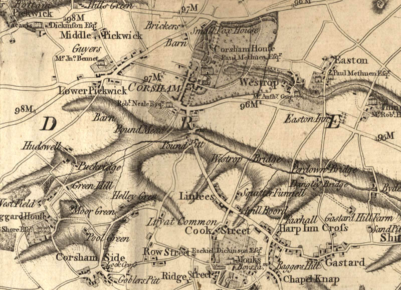
| Description | Extract of Andrews’ and Dury’s Map of Wiltshire, 1773, showing Corsham |
| Date |
|
| Source | |
| Author | Andrews and Dury |
| Permission (Reusing this file) |
|
Licensing
|
This is a faithful photographic reproduction of a two-dimensional, public domain work of art. The work of art itself is in the public domain for the following reason:
The official position taken by the Wikimedia Foundation is that "faithful reproductions of two-dimensional public domain works of art are public domain". This photographic reproduction is therefore also considered to be in the public domain in the United States. In other jurisdictions, re-use of this content may be restricted; see Reuse of PD-Art photographs for details. {{PD-Art}} template without license parameter: please specify why the underlying work is public domain in both the source country and the United States
(Usage: {{PD-Art|1=|deathyear=''year of author's death''|country=''source country''}}, where parameter 1= can be PD-old-auto, PD-old-auto-expired, PD-old-auto-1996, PD-old-100 or similar. See Commons:Multi-license copyright tags for more information.) | ||||
File history
Click on a date/time to view the file as it appeared at that time.
| Date/Time | Thumbnail | Dimensions | User | Comment | |
|---|---|---|---|---|---|
| current | 09:44, 10 October 2006 | | 800 × 580 (154 KB) | InfantGorilla | {{Information |Description=Extract of Andrews’ and Dury’s Map of Category:Wiltshire, 1773, showing w:Corsham |Source=*URL http://www.wiltshire.gov.uk/community/gallery/map/corsham_map.73.003.jpg *as seen on page http://www.wiltshire.gov.uk/c |
File usage
The following pages on the English Wikipedia use this file (pages on other projects are not listed):
Global file usage
The following other wikis use this file:
- Usage on azb.wiki.x.io
- Usage on de.wiki.x.io
- Usage on fa.wiki.x.io