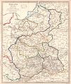
File:Congress Poland 1831.jpg
Appearance

Size of this preview: 505 × 600 pixels. Other resolutions: 202 × 240 pixels | 404 × 480 pixels | 646 × 768 pixels | 862 × 1,024 pixels | 1,724 × 2,048 pixels | 2,597 × 3,085 pixels.
Original file (2,597 × 3,085 pixels, file size: 1.32 MB, MIME type: image/jpeg)
File history
Click on a date/time to view the file as it appeared at that time.
| Date/Time | Thumbnail | Dimensions | User | Comment | |
|---|---|---|---|---|---|
| current | 16:56, 14 June 2010 |  | 2,597 × 3,085 (1.32 MB) | Cropbot | upload cropped version, operated by User:Yarl. Summary: cropped |
| 17:11, 10 July 2007 |  | 2,650 × 3,100 (1.35 MB) | Piotrus | {{Information |Description=Poland (Polska) Divided into Eight Palatinates or Woïwodies. 1:1,901,000 |Source=[http://alabamamaps.ua.edu/historicalmaps/europe/germany_prussia/poland.html] |Date= |Author=Society for the Diffusion of Useful Knowledge. London |
File usage
The following page uses this file:
Global file usage
The following other wikis use this file:
- Usage on be-tarask.wiki.x.io
- Usage on bg.wiki.x.io
- Usage on de.wiki.x.io
- Usage on es.wiki.x.io
- Usage on et.wiki.x.io
- Usage on hu.wiki.x.io
- Usage on it.wiki.x.io
- Usage on lt.wiki.x.io
- Usage on lv.wiki.x.io
- Usage on pl.wiki.x.io
- Małopolska
- Babsk (województwo łódzkie)
- Podział administracyjny Królestwa Polskiego
- Województwo kaliskie (Królestwo Polskie)
- Województwo podlaskie (Królestwo Polskie)
- Województwo augustowskie
- Województwo krakowskie (Królestwo Polskie)
- Województwo płockie (Królestwo Polskie)
- Województwo sandomierskie (Królestwo Polskie)
- Województwo lubelskie (Królestwo Polskie)
- Województwo mazowieckie (Królestwo Polskie)
- Związek Miast i Gmin Morskich
- Stocznia Szczecińska im. Adolfa Warskiego
- Usage on pt.wiki.x.io
- Usage on ru.wiki.x.io
- Usage on th.wiki.x.io
- Usage on uk.wiki.x.io
- Usage on zh.wiki.x.io
