
File:Bergen-13ème.jpg

Size of this preview: 553 × 600 pixels. Other resolutions: 221 × 240 pixels | 443 × 480 pixels | 832 × 902 pixels.
Original file (832 × 902 pixels, file size: 247 KB, MIME type: image/jpeg)
| This is a file from the Wikimedia Commons. Information from its description page there is shown below. Commons is a freely licensed media file repository. You can help. |
Summary
| Description |
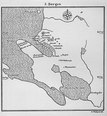
English: Map of Bergen (XIIIth century) drawn late XIXth century by G.Philip & son. Nouns with "-sk" endings are or were churches. Alrekstadir is know to be the first farm built in the area.
Français : Carte de Bergen au XIIIè siècle. Auteur: G.Philip & son, fin du XIXe siècle. Les noms finissant en "sk" sont des églises, dont plusieurs ont disparu. "castle" est en fait Sverreborg. Holmen est la forteresse de Bergenhus. Alrekstadir est la première construction Bergenoise, il s'agissait d'une ferme, désormais disparue. |
|||||
| Source | Unknown source | |||||
| Author | ||||||
| Permission (Reusing this file) |
|
|||||
File history
Click on a date/time to view the file as it appeared at that time.
| Date/Time | Thumbnail | Dimensions | User | Comment | |
|---|---|---|---|---|---|
| current | 00:42, 1 March 2007 | | 832 × 902 (247 KB) | Skygge~commonswiki | Carte de Bergen au XIIIè siècle. Auteur: G.Philip & son, fin du XIXè siècle. Map of Bergen (XIIIth century) drawn late XIXth century by G.Philip & son. Les noms finissant en "sk" sont des églises, dont plusieurs ont disparu. "castle" est en fait Sv |
File usage
The following pages on the English Wikipedia use this file (pages on other projects are not listed):
Global file usage
The following other wikis use this file:
- Usage on fr.wiki.x.io
- Usage on it.wiki.x.io
- Usage on no.wiki.x.io