
File:Ausschnitt der Vinland-Karte.jpg
Size of this preview: 800 × 542 pixels. Other resolutions: 320 × 217 pixels | 640 × 434 pixels | 1,024 × 694 pixels | 1,216 × 824 pixels.
Original file (1,216 × 824 pixels, file size: 278 KB, MIME type: image/jpeg)
| This is a file from the Wikimedia Commons. Information from its description page there is shown below. Commons is a freely licensed media file repository. You can help. |
Summary
| Description |
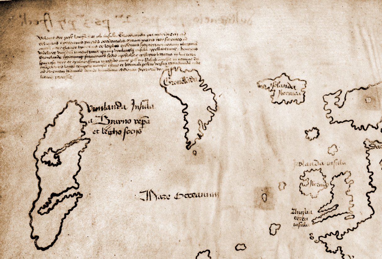
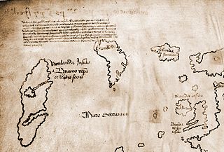
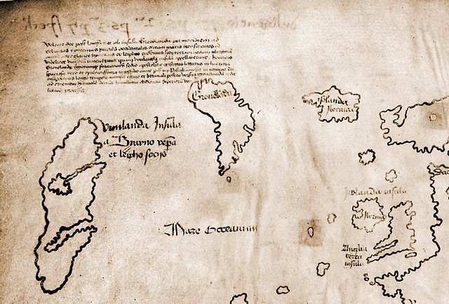
Deutsch: Ausschnitt der Vinland-Karte oben links |
| Source | Yale University; Original at http://www.bnl.gov/bnlweb/pubaf/pr/photos/2002/vinland.jpg |
| Author | Yale University Press |
| Other versions |
 |
Licensing
|
This work is in the public domain in its country of origin and other countries and areas where the copyright term is the author's life plus 70 years or fewer. | |
| This file has been identified as being free of known restrictions under copyright law, including all related and neighboring rights. | |
Original upload log
Transferred from de.wikipedia to Commons by Ireas using CommonsHelper.
The original description page was here. All following user names refer to de.wikipedia.
- 2010-11-12 11:21 Zuviele Interessen 1216×824× (284384 bytes) {{Information |Beschreibung = Ausschnitt der Vinland-Karte oben links{{en|The Vinland map / chart is purportedly a 15th century Mappa Mundi, redrawn from a 13th century original. Drawn with black ink on animal skin, if authentic the map is the first known depiction of the North American coastline, created before Columbus' 1492 voyage. The upper left caption reads: “By God's will, after a long voyage from the island of Greenland to the south toward the most distant remaining parts of the western ocean sea, sailing southward amidst the ice, the companions Bjarni and Leif riksson discovered a new land, extremely fertile and even having vines, ... which island they named Vinland.” Most scholars and scientists who have studied the map have concluded that it is a fake, probably drawn on old parchment in the 20th century.}} {{de|Die Vinland Mappe / Karte ist angeblich eine Weltkarte des 15. Jahrhunderts, neu gezeichnet von einem Original aus dem 13. Jahrhundert . Gezeichnet mit schwarzer Tinte auf Tierhaut, wenn sie echt wäre, wäre die Karte die erste bekannte Darstellung der nordamerikanischen Küste, die vor Kolumbus' Reise 1492. Im linken oberen Teil Inschrift: "Mit Gottes Willen, nach einer langen Reise von der Insel Grönland nach Süden durch das Eis segelnd zu den am weitesten entfernten übrigen Teilen des westlichen Ozeans, entdeckten die Gefährten Bjarni und Leif Erikssohn ein neues Land, äußerst fruchtbar und sogar mit Reben, eine Insel, die sie Vinland nannten" Die meisten Gelehrten und Wissenschaftler, die die Karte untersucht haben, kommen zu dem Schluss, dass die Karte eine Fälschung ist, die wahrscheinlich im 20. Jahrhundert auf alten Pergament gezeichnet wurde.}} {{fr|La carte du Vinland est une carte datant peut-être du XVe siècle, et reprenant un original du XIIIe siècle. Tracée à l'encre noire sur du parchemin, cette carte est la première carte connue montrant la côte de L'Amérique du Nord, et est plus ancienne que le voyage de Christophe Collomb (1492). La légende en haut à gauche se lit “Par la volonté de Dieu et après un long voyage depuis l'île du Groenland vers les parts les plus lointaines de la mer océane de l'ouest, naviguant au sud au milieu des glaces, les compagnons Bjarni et Leif Eiriksson découvrirent une nouvelle terre, très fertile et portant de la vigne [...] ils la nommèrent Vinland.” La plupart des études au sujet de cette carte suggèrent qu'elle est truquée, dessinée au 20me siècle sur deux feuilles de parchemin anciennes. }} |Quelle = Yale University |Urheber = Yale University Press |Datum = |Genehmigung = |Andere Versionen = Vinland Map HiRes.jpg |Anmerkungen = Quelldatei http://de.wiki.x.io/wiki/Datei:Vinland_Map_HiRes.jpg }}
File history
Click on a date/time to view the file as it appeared at that time.
| Date/Time | Thumbnail | Dimensions | User | Comment | |
|---|---|---|---|---|---|
| current | 01:17, 13 November 2010 | | 1,216 × 824 (278 KB) | File Upload Bot (Magnus Manske) | {{BotMoveToCommons|de.wikipedia|year={{subst:CURRENTYEAR}}|month={{subst:CURRENTMONTHNAME}}|day={{subst:CURRENTDAY}}}} {{Information |Description={{de|Ausschnitt der Vinland-Karte oben links}} |Source=Transferred from [http://de.wiki.x.io de.wikipedi |
File usage
No pages on the English Wikipedia use this file (pages on other projects are not listed).
Global file usage
The following other wikis use this file:
- Usage on de.wiki.x.io
- Usage on fr.wiki.x.io
- Usage on he.wiki.x.io