
File:Amurrivermap.png

Size of this preview: 761 × 599 pixels. Other resolutions: 305 × 240 pixels | 610 × 480 pixels | 989 × 779 pixels.
Original file (989 × 779 pixels, file size: 298 KB, MIME type: image/png)
| This is a file from the Wikimedia Commons. Information from its description page there is shown below. Commons is a freely licensed media file repository. You can help. |
| Description |
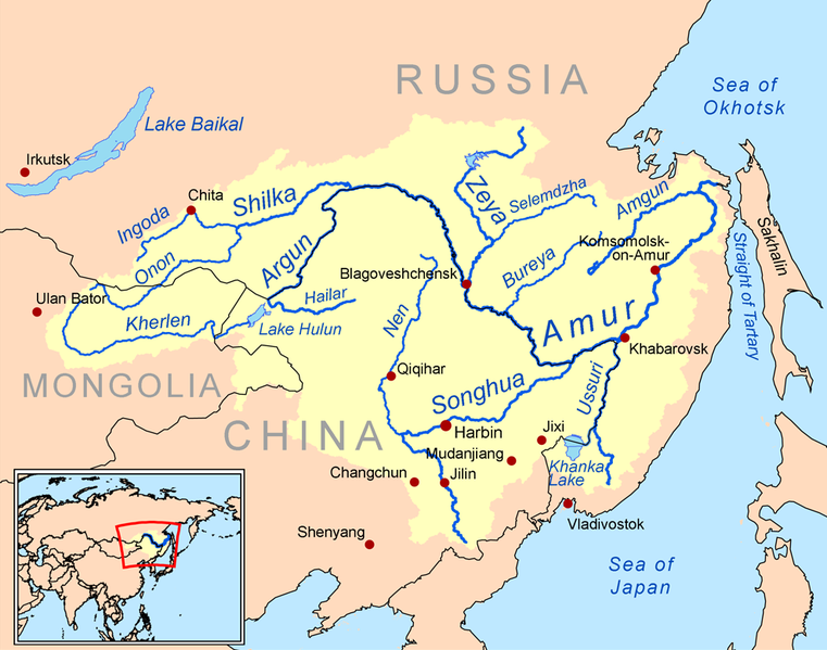
English: This is a map of the Amur River drainage basin. Русский: Карта бассейна реки Амур. |
| Date | |
| Source | Own work using Digital Chart of the World and GTOPO data. |
| Author | Kmusser |
| Other versions |
Derivative works of this file: Amurriversourcesmap.jpg File:Amur watershed.png |
I, the copyright holder of this work, hereby publish it under the following license:
This file is licensed under the Creative Commons Attribution-Share Alike 3.0 Unported license.
- You are free:
- to share – to copy, distribute and transmit the work
- to remix – to adapt the work
- Under the following conditions:
- attribution – You must give appropriate credit, provide a link to the license, and indicate if changes were made. You may do so in any reasonable manner, but not in any way that suggests the licensor endorses you or your use.
- share alike – If you remix, transform, or build upon the material, you must distribute your contributions under the same or compatible license as the original.

|
This map image could be re-created using vector graphics as an SVG file. This has several advantages; see Commons:Media for cleanup for more information. If an SVG form of this image is available, please upload it and afterwards replace this template with
{{vector version available|new image name}}.
It is recommended to name the SVG file “Amurrivermap.svg”—then the template Vector version available (or Vva) does not need the new image name parameter. |
File history
Click on a date/time to view the file as it appeared at that time.
| Date/Time | Thumbnail | Dimensions | User | Comment | |
|---|---|---|---|---|---|
| current | 01:15, 7 June 2010 | | 989 × 779 (298 KB) | Ras67 | cropped |
| 20:05, 2 March 2009 |  | 1,000 × 795 (367 KB) | Kmusser | {{Information |Description=This is a map of the Amur River drainage basin. |Source=Own work using [http://www.maproom.psu.edu/dcw/ Digital Chart of the World] and [http://edc.usgs.gov/products/elevation/gtopo30/gtopo30.html GTOPO] data. |
File usage
The following 13 pages use this file:
Global file usage
The following other wikis use this file:
- Usage on af.wiki.x.io
- Usage on als.wiki.x.io
- Usage on ar.wiki.x.io
- Usage on arz.wiki.x.io
- Usage on ast.wiki.x.io
- Usage on azb.wiki.x.io
- Usage on be-tarask.wiki.x.io
- Usage on bg.wiki.x.io
- Usage on bh.wiki.x.io
- Usage on bn.wiki.x.io
- Usage on br.wiki.x.io
- Usage on bs.wiki.x.io
- Usage on ca.wiki.x.io
- Usage on crh.wiki.x.io
- Usage on cy.wiki.x.io
- Usage on da.wiki.x.io
- Usage on de.wiki.x.io
- Usage on eo.wiki.x.io
- Usage on es.wiki.x.io
View more global usage of this file.