
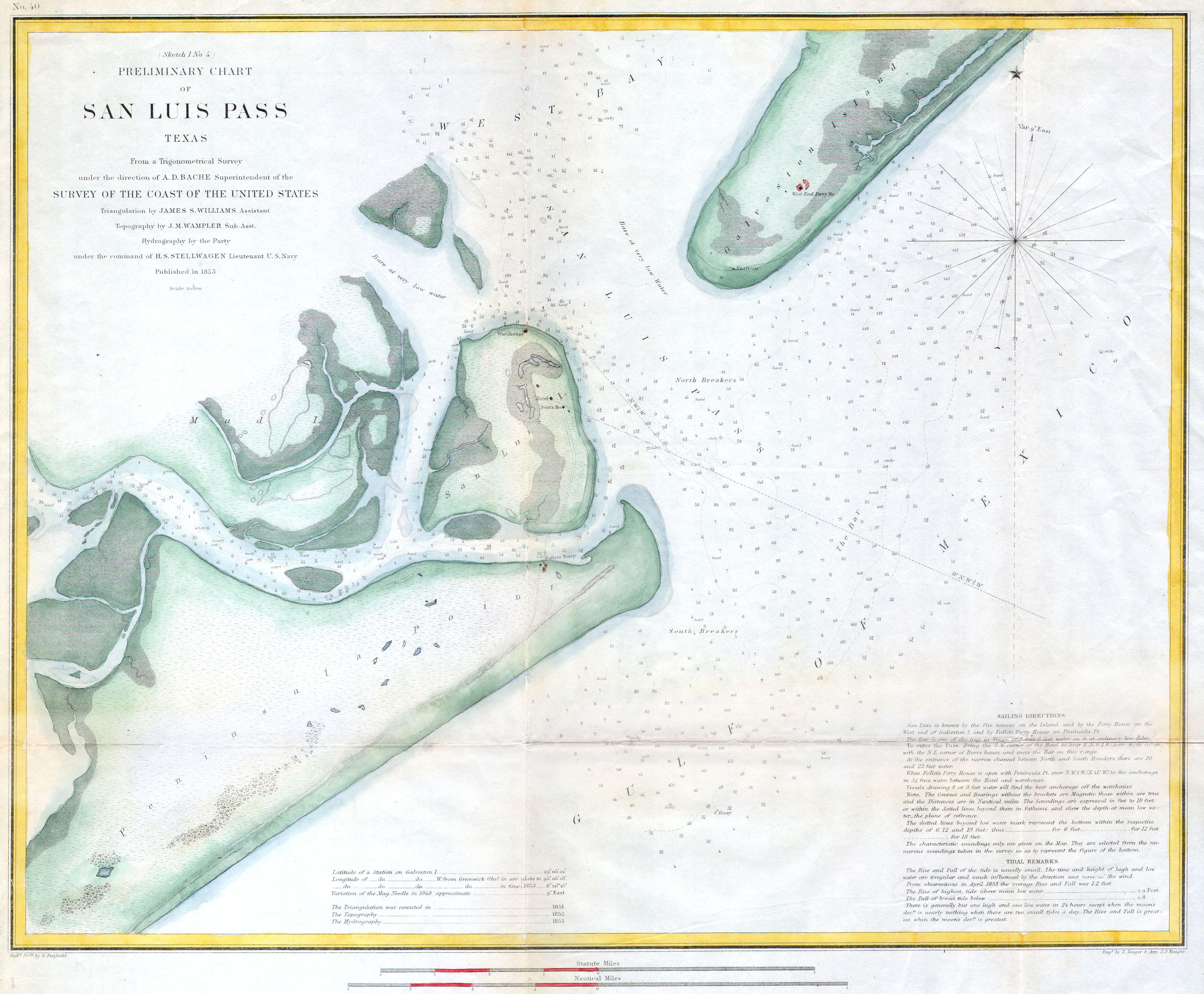
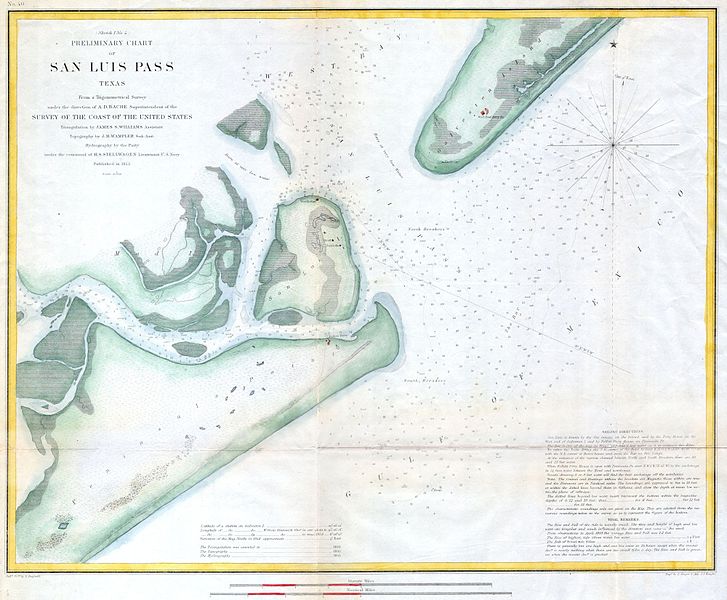
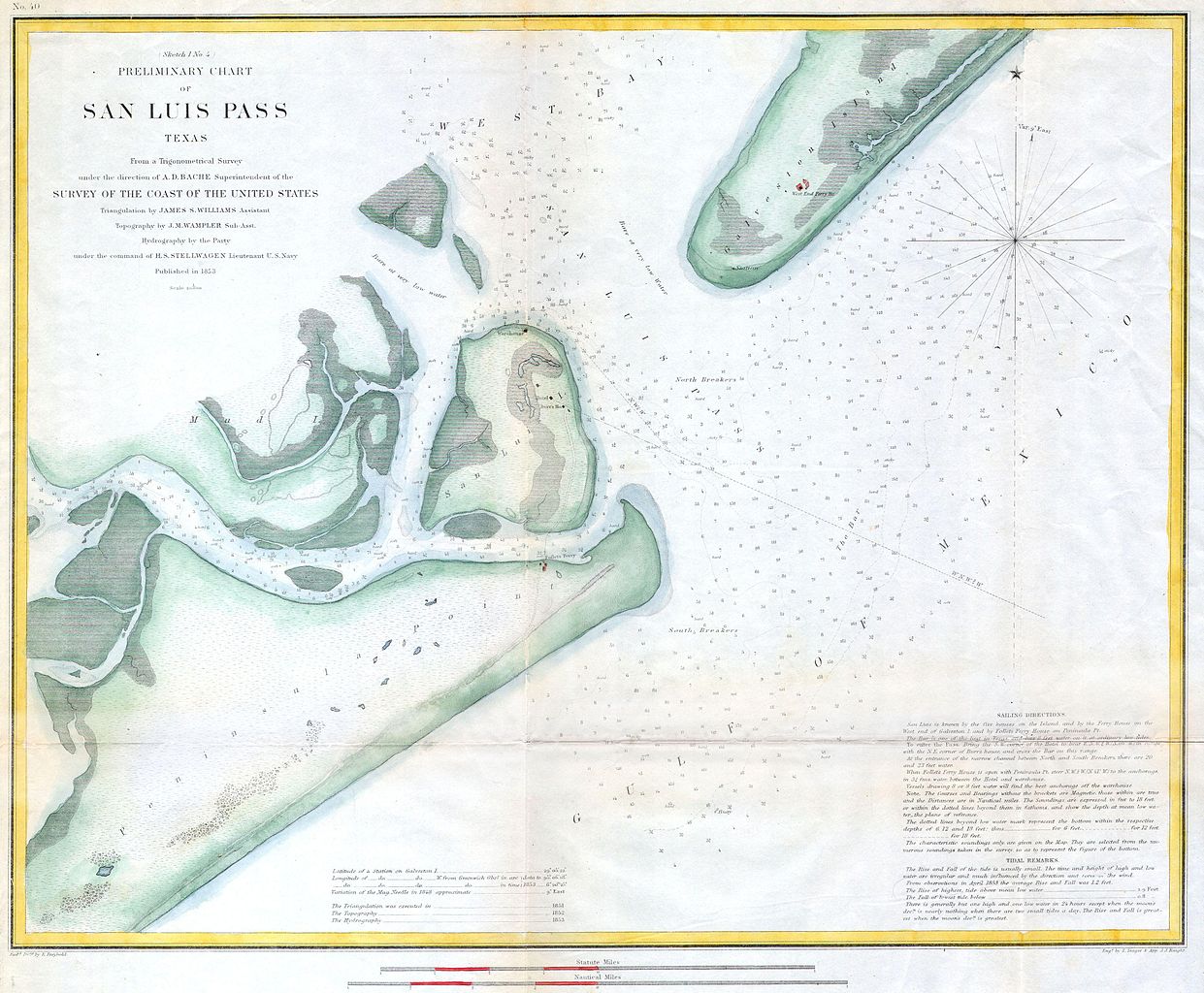
File:1853 U.S.C.S. Coast Chart or Map of San Luis Pass, Texas - Geographicus - SanLuisPass-uscs-1853.jpg
Original file (4,000 × 3,301 pixels, file size: 1.86 MB, MIME type: image/jpeg)
| This is a file from the Wikimedia Commons. Information from its description page there is shown below. Commons is a freely licensed media file repository. You can help. |
| (Sketch 1 No. 4) Preliminary Chart of San Luis Pass Texas. | ||||||
|---|---|---|---|---|---|---|
| Artist | ||||||
| Title |
(Sketch 1 No. 4) Preliminary Chart of San Luis Pass Texas. |
|||||
| Description |
English: A rare hand colored 1853 costal chart of San Luis Pass or the entrance to Galveston harbor, Texas. Features Peninsula Point, Follet’s Ferry, San Luis Island, Mud Island and Galveston Island. There is a otel indicated on San Luis Island. Includes detailed sailing instructions, depth soundings, and impressive inland detail of the city of Galveston and vicinity. Triangulations were accomplished by J. M Wampler and J.S. Williams, under the direction of H.S. Stellwagen. Published under the supervision of A. D. Bache for the 1853 Report of the Superintendant of the U.S. Coast Survey. |
|||||
| Date | 1853 | |||||
| Dimensions | height: 14 in (35.5 cm); width: 17 in (43.1 cm) | |||||
| Accession number |
Geographicus link: SanLuisPass-uscs-1853 |
|||||
| Source/Photographer |
|
|||||
| Permission (Reusing this file) |
|
|||||
File history
Click on a date/time to view the file as it appeared at that time.
| Date/Time | Thumbnail | Dimensions | User | Comment | |
|---|---|---|---|---|---|
| current | 20:36, 15 March 2011 | | 4,000 × 3,301 (1.86 MB) | BotMultichill | {{subst:User:Multichill/Geographicus |link=http://www.geographicus.com/P/AntiqueMap/SanLuisPass-uscs-1853 |product_name=1853 U.S.C.S. Coast Chart or Map of San Luis Pass, Texas |map_title=(Sketch 1 No. 4) Preliminary Chart of San Luis Pass Texas. |desc |
File usage
Global file usage
The following other wikis use this file:
- Usage on es.wiki.x.io