
File:1849 Mitchell Map of Turkey ( Iraq, Syria, Palestine ) - Geographicus - TurkeyAsia-m-1849.jpg

Size of this preview: 732 × 600 pixels. Other resolutions: 293 × 240 pixels | 586 × 480 pixels | 938 × 768 pixels | 1,250 × 1,024 pixels | 2,501 × 2,048 pixels | 4,000 × 3,276 pixels.
Original file (4,000 × 3,276 pixels, file size: 2.89 MB, MIME type: image/jpeg)
| This is a file from the Wikimedia Commons. Information from its description page there is shown below. Commons is a freely licensed media file repository. You can help. |
_-_Geographicus_-_TurkeyAsia-m-1849.jpg)
| Samuel Augustus Mitchell: Turkey in Asia.
( |
||||||||||||||||||||
|---|---|---|---|---|---|---|---|---|---|---|---|---|---|---|---|---|---|---|---|---|
| Artist |
|
|||||||||||||||||||
| Title |
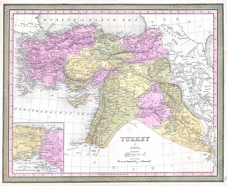
Turkey in Asia. |
|||||||||||||||||||
| Description |
English: This beautiful hand colored map is a lithographic engraving of Turkey in Asia, dating to 1849. Beautiful map depicts most of modern day nations of Turkey, Iran, Iraq, Israel, Palestine, Jordan, Syria, Lebanon and Kuwait. There is a beautiful inset of the Environs of Constantinople or Istanbul. Produced by the legendary American map publisher S. A. Mitchell Sr. in conjunction with the Cowperthwait firm of Philadelphia, PA. |
|||||||||||||||||||
| Date | 1849 | |||||||||||||||||||
| Dimensions | height: 12.5 in (31.7 cm); width: 15.5 in (39.3 cm) | |||||||||||||||||||
| Accession number |
Geographicus link: TurkeyAsia-m-1849 |
|||||||||||||||||||
| Source/Photographer |
|
|||||||||||||||||||
| Permission (Reusing this file) |
|
|||||||||||||||||||
File history
Click on a date/time to view the file as it appeared at that time.
| Date/Time | Thumbnail | Dimensions | User | Comment | |
|---|---|---|---|---|---|
| current | 21:03, 15 March 2011 | | 4,000 × 3,276 (2.89 MB) | BotMultichill | {{subst:User:Multichill/Geographicus |link=http://www.geographicus.com/P/AntiqueMap/TurkeyAsia-m-1849 |product_name=1849 Mitchell Map of Turkey ( Iraq, Syria, Palestine ) |map_title=Turkey in Asia. |description=This beautiful hand colored map is a lithogr |
File usage
The following pages on the English Wikipedia use this file (pages on other projects are not listed):
Global file usage
The following other wikis use this file:
- Usage on ar.wiki.x.io
- Usage on azb.wiki.x.io
- Usage on az.wiki.x.io
- Usage on bn.wiki.x.io
- Usage on fa.wiki.x.io
- Usage on it.wiki.x.io
- Usage on ja.wiki.x.io
- Usage on ko.wiki.x.io
- Usage on ms.wiki.x.io
- Usage on ru.wiki.x.io
- Usage on sl.wiki.x.io
- Usage on sq.wiki.x.io
- Usage on tr.wiki.x.io
- Usage on uk.wiki.x.io
- Usage on www.wikidata.org
- Usage on zh.wiki.x.io
_-_Geographicus_-_TurkeyAsia-m-1849.jpg)