
File:1513 Piri Reis.jpg

Size of this preview: 435 × 599 pixels. Other resolutions: 174 × 240 pixels | 349 × 480 pixels | 558 × 768 pixels | 744 × 1,024 pixels | 2,000 × 2,753 pixels.
Original file (2,000 × 2,753 pixels, file size: 2.29 MB, MIME type: image/jpeg)
| This is a file from the Wikimedia Commons. Information from its description page there is shown below. Commons is a freely licensed media file repository. You can help. |
Summary
| Description |
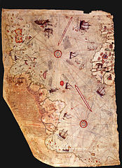
English: A peculiar map drawn by the Turkish admiral Piri Reis around 1513, showing parts of the earth nowadays covered with ice. |
||||||||||||||||||||
| Date | circa 1513 | ||||||||||||||||||||
| Source | http://www.ufonetwork.it | ||||||||||||||||||||
| Author |
|
||||||||||||||||||||

Licensing
|
This work is in the public domain in its country of origin and other countries and areas where the copyright term is the author's life plus 70 years or fewer. | |
| This file has been identified as being free of known restrictions under copyright law, including all related and neighboring rights. | |
File history
Click on a date/time to view the file as it appeared at that time.
| Date/Time | Thumbnail | Dimensions | User | Comment | |
|---|---|---|---|---|---|
| current | 10:20, 15 April 2007 | | 2,000 × 2,753 (2.29 MB) | Joopr | A peculiar map drawn by the Turkish admiral Piri Reis around 1513, showing parts of the earth nowadays covered with ice. Also to be found at: www.ufonetwork.it |
File usage
The following pages on the English Wikipedia use this file (pages on other projects are not listed):
Global file usage
The following other wikis use this file:
- Usage on ast.wiki.x.io
- Usage on es.wiki.x.io
- Usage on eu.wiki.x.io
- Usage on hu.wiki.x.io
- Usage on ro.wiki.x.io
- Usage on tr.wikiquote.org