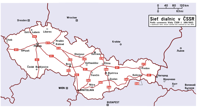
File:ČSSR 1963.svg
Appearance

Size of this PNG preview of this SVG file: 800 × 445 pixels. Other resolutions: 320 × 178 pixels | 640 × 356 pixels | 1,024 × 569 pixels | 1,280 × 711 pixels | 2,560 × 1,422 pixels | 1,276 × 709 pixels.
Original file (SVG file, nominally 1,276 × 709 pixels, file size: 418 KB)
File history
Click on a date/time to view the file as it appeared at that time.
| Date/Time | Thumbnail | Dimensions | User | Comment | |
|---|---|---|---|---|---|
| current | 12:05, 28 July 2010 |  | 1,276 × 709 (418 KB) | Rl91 | diagrams of route signs |
| 11:27, 28 July 2010 |  | 1,276 × 709 (331 KB) | Rl91 | mistake | |
| 11:26, 28 July 2010 |  | 1,276 × 709 (331 KB) | Rl91 | ZA-Č.Těšín | |
| 11:23, 28 July 2010 |  | 1,276 × 709 (331 KB) | Rl91 | == Summary == {{Information |Description={{en|1=Map of planned motorways in ČSSR 1963}} {{sk|1=Mapa siei plánových diaľnic v ČSSR 1963}} |Source={{own}} |Author=Rl91 |Date=28.7.2010 |Permission= |other_versions= }} [[Category:Czechoslo |
File usage
The following 2 pages use this file:
Global file usage
The following other wikis use this file:
- Usage on cs.wiki.x.io
- Usage on fr.wiki.x.io
- Usage on pl.wiki.x.io
- Usage on sk.wiki.x.io
- Usage on sv.wiki.x.io
