Omuma Local Government
Omuma | |
|---|---|
| Coordinates: 5°5′12″N 7°13′59″E / 5.08667°N 7.23306°E | |
| Country | Nigeria |
| State | Rivers State |
| Date created | October 1, 1996[citation needed] |
| Seat | Eberi |
| Government | |
| • Local Government Chairman | Nwaiwu Chisorom (PDP) |
| • Deputy Local Government Chairman | Ubani Mary (PDP) |
| • Local Government Council | Ward 1: Umesi Obioma (PDP) Ward 2: Promise Reginald (PDP) Ward 3: Ekpendu Prince Eze (PDP) Ward 4: Elike Nwaobia Samuel (PDP) Ward 5: Henry Okechukwu (PDP) Ward 6: Ugochukwu Orji (PDP) Ward 7: Cyril Oluo (PDP) Ward 8: Nwaodu Nnanyibu (PDP) Ward 9: Onyebuchi Onyeche (PDP) Ward 10: Okpoko Lucky (PDP) |
| Area | |
| • Total | 70 sq mi (170 km2) |
| Time zone | UTC+1 (WAT) |
 | |
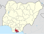
Omuma is a Local Government Area in Rivers State, South South geopolitical zone of Nigeria.[1] Its headquarters are in the town of Eberi. Its people are Igbo .[2] It was created in the year 1989.
It has an area of 170 km2 (66 sq mi) and a population of 100,366 at the 2006 census[citation needed].
The postal code of the area is 512.[3][4] The local government area is made up of several towns and villages such as Umuabali, Umuroke, Eberi, Egbelu, Umuokwa, Umuoroyo and Umudik. A number of festival such as the Ogwu Ekpeye festival are held in omuma local government area.[1] Christianity is widely practiced in Omuma local government area. With the average humidity level of 78 percent in the LGA, it hosts a number of Rivers and tributaries. [1] it's has a vibrant trade sector and hosts a number of markets such as the Eketa market where a variety of commodities are bought and sold.[1] Omuma local government area is also an agricultural hub with crops such as yam, maize, Palm oil and vegetables.[1] Other economic activities engaged in by the people include fishing, crafts making, lumbering and hunting.[1]
References
[edit]- ^ a b c d e f "Nigeria Business Directory - Find Companies, People & Places in Nigeria". www.manpower.com.ng. Retrieved 2023-04-29.
- ^ "State map". Nigerian National Bureau of Statistics. Archived from the original on 2010-05-01. Retrieved 2010-05-19.
- ^ "Post Offices- with map of LGA". NIPOST. Archived from the original on 2012-11-26. Retrieved 2009-10-20.
- ^ "Omuma Local Government Area".


