Eastside Park (neighborhood), Paterson
Eastside Park Historic District | |
 Entrance to Eastside Park | |
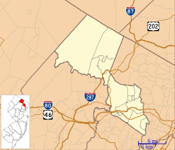
| Location | Roughly bounded by 20th, Vreeland, and 11th Avenues, E. 33rd Street and Mclean Boulevard, Paterson, New Jersey |
|---|---|
| Coordinates | 40°54′50″N 74°8′24″W / 40.91389°N 74.14000°W |
| Area | 300 acres (120 ha) |
| Built | 1888 |
| Architect | Fred Wesley Wentworth; Welch, Smith and Provot; John Y. Culyer |
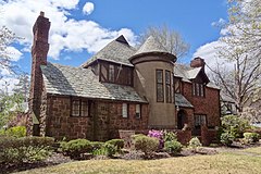
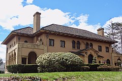
| Architectural style | Colonial Revival, Tudor Revival |
| NRHP reference No. | 04000673[1] |
| NJRHP No. | 2372[2] |
| Significant dates | |
| Added to NRHP | July 7, 2004 |
| Designated NJRHP | May 10, 2004 |
Eastside Park is a residential neighborhood in the Eastside of Paterson, New Jersey. The Eastside Park section of the city is generally defined as the area of the city bordered by Vreeland Avenue and East 33rd Street (both part of the "old" York Road) to the west, 20th Avenue to the south, McLean Boulevard (Route 20) to the east, and Martin Luther King, Jr. Way (Broadway) to the north. The Eastside Park section is delineated from the Manor section of the city by Broadway, which becomes Route 4 before crossing the Passaic River into Elmwood Park (formerly East Paterson) in Bergen County.
History
[edit]Once the home of the city's industrial and political leaders, the neighborhood experienced a significant downturn as industry fled Paterson. In recent years, people have begun moving back into the neighborhood and are restoring some of the area's historic houses.[3][4][5] The jewel of the neighborhood remains Eastside Park and the mansions that surround it. In addition, this section of Paterson once had a large Jewish population, with the original sites of Barnert Temple and Temple Emanuel both situated in the section. The Eastside Park neighborhood now houses the Paterson campus of the Islamic Center of Passaic County, one of the largest Muslim communities in the United States, which serves a congregant base of over 25,000 people.
Historic district
[edit]The Eastside Park Historic District is a historic district situated across both the Eastside Park and Manor sections of the city. It was added to the National Register of Historic Places on July 7, 2004, for its significance in architecture, landscape architecture and community planning. The district includes 790 contributing buildings.[6]
Gallery
[edit]-
Charles Van Buren farmhouse, the White House
-
Tudor Revival style house
-
Italian Renaissance style house
-
Tudor Revival style house
References
[edit]- ^ "National Register Information System – (#04000673)". National Register of Historic Places. National Park Service. November 2, 2013.
- ^ "New Jersey and National Registers of Historic Places - Passaic County" (PDF). New Jersey Department of Environmental Protection - Historic Preservation Office. December 28, 2020. p. 6.
- ^ "Mansions Are at Home in Eastside Park - WSJ". wsj.com. Retrieved November 27, 2016.
- ^ BARBARA WILLIAMS. "A lot of house for the money in Eastside Park, Paterson - Business - NorthJersey.com". northjersey.com. Retrieved November 27, 2016.
- ^ "Spotlight: Eastside Park, Paterson, New Jersey | LegalTowns". legaltowns.wordpress.com. Retrieved November 27, 2016.
- ^ Esser, Phillip S.; Graziano, Paul D. (August 7, 2003). "National Register of Historic Places Inventory/Nomination: Eastside Park Historic District". National Park Service. With accompanying 77 photos
External links
[edit] Media related to Eastside Park Historic District at Wikimedia Commons


